Middle Caicos Airport | |||||||||||
|---|---|---|---|---|---|---|---|---|---|---|---|
| Summary | |||||||||||
| Airport type | Public | ||||||||||
| Serves | Middle Caicos, Turks and Caicos Islands | ||||||||||
| Elevation AMSL | 9 ft / 3 m | ||||||||||
| Coordinates | 21°49′33″N 071°48′09″W / 21.82583°N 71.80250°W | ||||||||||
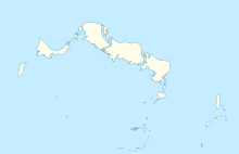
| Map | |||||||||||
| Runways | |||||||||||
| |||||||||||
Source:
[1] | |||||||||||
Middle Caicos Airport ( IATA: MDS, ICAO: MBMC) is an airport serving Middle Caicos (also known as Grand Caicos), [1] the largest island in the Turks and Caicos Islands.
Facilities
The airport is at an elevation of 9 ft (3 m) above mean sea level. It has one runway which is 750 m × 30 m (2,461 ft × 98 ft). [1]
References
- ^ a b c Airport information for Middle Caicos, Turks and Caicos Islands (MBMC / MDS) at Great Circle Mapper.
External links
