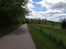
Miami Whitewater Forest is the largest park in the Great Parks of Hamilton County with 4,345 acres (17.58 km2). It is located in Hamilton County, Ohio, just northwest of Cincinnati. Included in the park are the 7.8-mile (12.6 km) paved Shaker Trace Trail as well as many other shorter trails. [1] There is also a golf course, a 46-acre (19 ha) campground, horseback riding, and many sports offered. [2] 46 modern campsites are available, with electric hookups and a fire pit. [3]
In 2009 the park district spent $60,000 to build a brush recycling center at the park, and another $13,000 to build ponds for fishing bluegill. [4]
In 2015 the Hamilton County park opened a dog park. It is the second dog park in the county park system.
References
- ^ Molloy, Johnny (Apr 17, 2012). Best Hikes Near Cincinnati. Globe Pequot. p. 15. ISBN 9780762785636. Retrieved 2013-05-18.
- ^ Guide to Miami Whitewater Forest at CincinnatiUSA.com
- ^ "Park district taking camping reservations for this summer". Cincinnati Enquirer. 27 February 2013. ProQuest 1312682557.
- ^ Jessica Brown (23 January 2009). "$32.1M plan adds acreage, playgrounds". Cincinnati Enquirer. ProQuest 237658629.
External links
39°15′43″N 84°44′31″W / 39.262°N 84.742°W