Międzybórz | |
|---|---|
 Holy Cross Church and clergy house | |
 Coat of arms | |
 Międzybórz | |
| Coordinates: 51°23′57″N 17°39′56″E / 51.39917°N 17.66556°E | |
| Country | |
| Voivodeship | Lower Silesian |
| County | Oleśnica |
| Gmina | Międzybórz |
| Area | |
| • Total | 6.41 km2 (2.47 sq mi) |
| Population (2019-06-30
[1]) | |
| • Total | 2,341 |
| • Density | 370/km2 (950/sq mi) |
| Time zone | UTC+1 ( CET) |
| • Summer ( DST) | UTC+2 ( CEST) |
| Postal code | 56-513 |
| Website | miedzyborz.pl |
Międzybórz [mʲɛnˈd͡zɨbuʂ], also known as Międzybórz Sycowski ( German: Neumittelwalde, until 1886 Medzibor), is a town in Oleśnica County, Lower Silesian Voivodeship, in south-western Poland. It is the seat of the administrative district ( gmina) called Gmina Międzybórz.
It lies approximately 30 kilometres (19 mi) north-east of Oleśnica, and 54 kilometres (34 mi) north-east of the regional capital Wrocław.
The settlement was first mentioned in 1228, when it was part of fragmented Poland. From 1313 it was part of the Duchy of Oleśnica, remaining ruled by the Piast dynasty until 1492. The town's name is of Polish origin, meaning "między borami", that is "between forests". [2] It received town privileges in 1637. Since the 19th century it has been a centre of the Polish Protestant faith. As at 2019, the town has a population of 2,341.
Gallery
-
 Saint Joseph church
 -
 Holy Cross church
 -
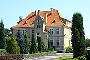 Old manor house


References
- ^ "Population. Size and structure and vital statistics in Poland by territorial division in 2019. As of 30th June". stat.gov.pl. Statistics Poland. 2019-10-15. Retrieved 2020-02-14.
- ^ Heinrich Adamy, Die Schlesischen Ortsnamen ihre entstechung und bedeutung, 1888, p. 35-36
| Town and seat | | |
|---|---|---|
| Villages | ||
| International | |
|---|---|
| National | |
|
| This Oleśnica County location article is a stub. You can help Wikipedia by expanding it. |