-
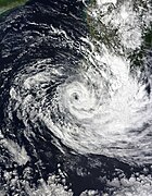
 21 February: Freddy continuing to inch closer to the east coast of Madagascar
 -
 22 February: Freddy substantially weakened as it traversed the mountainous terrain of Madagascar.
 -
 23 February: Freddy regenerating over the Mozambique Channel.
 -
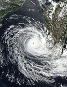
 24 February: Freddy nearing Mozambique
 -
 25 February: Freddy moving over Mozambique.
 Track of Cyclone Freddy, according to the
Saffir-Simpson scale | |
| Meteorological history | |
|---|---|
| Formed | 5 February 2023 |
| Dissipated | 14 March 2023 |
| Duration | 5 weeks and 2 days |
| Very intense tropical cyclone | |
| 10-minute sustained ( MFR) | |
| Highest winds | 230 km/h (145 mph) |
| Lowest pressure | 927 hPa ( mbar); 27.37 inHg |
| Category 5-equivalent tropical cyclone | |
| 1-minute sustained ( SSHWS/ JTWC) | |
| Highest winds | 270 km/h (165 mph) |
| Lowest pressure | 918 hPa ( mbar); 27.11 inHg |
| Overall effects | |
| Areas affected |
|
Part of the 2022–23 Australian region and South-West Indian Ocean cyclone seasons | |
Cyclone Freddy was the longest-lived tropical cyclone on record, beating the previous record of Hurricane John in 1994. [1] It also has the highest accumulated cyclone energy (ACE) of any tropical cyclone on record worldwide, surpassing Hurricane Ioke in 2006. [1] Additionally, Freddy is the only known tropical cyclone to achieve seven separate rapid intensification cycles. [2] While in the Australian region cyclone basin, the storm quickly intensified and became a Category 4 severe tropical cyclone, before it moved into the South-West Indian Ocean basin. The Joint Typhoon Warning Center (JTWC) estimated Freddy's peak strength, equivalent to Category 5 strength on the Saffir–Simpson scale. The Météo-France (MFR) upgraded it to a very intense tropical cyclone. Freddy made its first landfall near Mananjary, Madagascar. Freddy rapidly weakened overland but re-strengthened in the Mozambique Channel. Soon afterward, Freddy made its second landfall just south of Vilankulos, Mozambique.
The remnant low of Freddy began to acquire tropical characteristics after re-emerging into the channel. Soon after, Freddy intensified, becoming a tropical cyclone. Then, Freddy made its final landfall in Quelimane, Zambezia Province, Mozambique, Freddy gradually deteriorated and last noted on 14 March. Catastrophic flooding and extensive wind damage ensued, resulting in 1,434 fatalities across Madagascar, Mozambique, Malawi, Mauritius, and Zimbabwe, making it the third-deadliest tropical cyclone recorded in the Southern Hemisphere, only behind 2019's Cyclone Idai and the 1973 Flores cyclone. Total damages are estimated to reach $655 million, making it the second-costliest cyclone in the south-west Indian Ocean after Idai in 2019.
Origin and intensification

The presence of the Madden–Julian Oscillation and an equatorial Rossby wave in the Australian region contributed to the formation of tropical low over the north of Western Australia. [3] A tropical low was originally identified south of Bali, Indonesia early on 5 February. [4] Originally, the circulation was poorly defined and elongated, but in the evening and overnight, persistent convection occurred and began to show signs of improvement in the organization. [4] [5] During 6 February, the Joint Typhoon Warning Center (JTWC) [nb 1] issued a Tropical Cyclone Formation Alert (TCFA) on the system. [7] By 09:00 UTC, the JTWC initiated advisories on the system and classified it as Tropical Cyclone 11S. [8]

During a period of rapid development while moving slowly south-southwest, the Australian Bureau of Meteorology (BoM) [nb 2] stated that the tropical low had strengthened into a Category 1 tropical cyclone on the Australian tropical cyclone intensity scale and was given the name Freddy. [4] [10] [11] Later that next day, feeder bands were covering its very broad central dense overcast (CDO), prompting the JTWC to upgrade the system to a Category 1-equivalent cyclone. [12] The BoM subsequently followed suit and upgraded Freddy into a Category 2 tropical cyclone. [13] Freddy attained Category 3 cyclone. [14] Freddy began showing an eye feature seen in microwave imaging, with Freddy later becoming a Category 2-equivalent cyclone. [15]
Freddy weakened slightly due to CDO and a persistent area of cold cloud tops. [16] Weakening occurred as the JTWC assessed that Freddy's winds bottomed out at 150 km/h (90 mph). [17] Freddy weakened back into a tropical storm, and the BoM estimated winds of 100 km/h (65 mph), the weakening resulting from easterly wind shear. [18] [19] Continuing to rapidly intensify, Freddy became a Category 3-equivalent cyclone around 15:00 UTC on 11 February. [20] Freddy had further intensified to a Category 4 severe tropical cyclone due to the presence of a well-defined eye surrounded by deep convection. [21] Freddy intensified into a Category 4-equivalent cyclone with a symmetric CDO. [22] According to the JTWC, Freddy gradually became disorganized, with its eye no longer well-defined, and Freddy fell to 185 km/h (115 mph) winds. [23]
The BoM also reported that Freddy's winds weakened to 155 km/h (100 mph). [24] Despite easterly vertical wind shear, Freddy maintained a symmetric convective core. [25] The cyclone's ragged and cloud filled eye appeared on satellite imagery. [26] At 12:00 UTC on 14 February, Freddy crossed 90° E into the South-West Indian Ocean basin, and was immediately classified as a tropical cyclone by Météo-France (MFR) [nb 3] [28] [29] The MFR upgraded the system to an intense tropical cyclone. [30] Freddy exhibited highly symmetrical and annular characteristics around 03:00 UTC on 15 February. [31] Later the next day, the JTWC also assessed Freddy as having 1-minute maximum sustained winds of 270 km/h (165 mph), making the storm a Category 5-equivalent tropical cyclone, [32] [33] as the cyclone sustained a symmetric ring around deep convection. [34] During 18 February, Freddy began to rapidly deteriorate as a sudden spike in mid-level shear began impacting the storm. [35]
Strengthening and weakening

The cyclone briefly weakened to 1-minute sustained winds of 205 km/h (125 mph) before restrengthening once again. [36] Later that next day, Freddy was upgraded to a very intense tropical cyclone. [37] Shortly afterward, Freddy's cloud pattern slightly deteriorated, causing the cyclone to weaken to an intense tropical cyclone by 00:00 UTC on 20 February. [38] Freddy passed north of Mauritius and Réunion [39] and weakened to a tropical cyclone on 21 February. [40] At about 7 p.m. local time that day, the cyclone made its first landfall near Mananjary, Madagascar. [41] After landfall, Freddy was re-classified as an overland depression, with sustained winds of 110 km/h (70 mph). [42] The JTWC also reported that Freddy substantially weakened as it traversed the mountainous terrain of Madagascar, and was downgraded to 130 km/h (80 mph). [43] During 22 February, Freddy significantly improved in organization as it moved southwestward across the Mozambique Channel. [44] Freddy re-strengthened into a zone of disturbed weather. [44] [45] Freddy had re-developed under the deep convection in the northern semicircle of the circulation. [46] Freddy re-strengthened into a moderate tropical storm after the convection began to rapidly increase. [47] The system passed to the north of Europa Island. [48]
Freddy re-strengthened further, marking its intensification into a severe tropical storm. [49] Freddy continued to organize with convective bands wrapping into the center. [50] Six hours later, the cloud pattern deteriorated, as it approached the coast of Mozambique. [51] By 12:00 UTC on 24 February, the MFR reported that Freddy had made its second landfall in Mozambique south of Vilankulos, with 10-sustained winds of 85 km/h (50 mph). [52] Shortly after the landfall, the JTWC discontinued warnings about the system. [53] Freddy rapidly weakened as it moved westward and further inland, weakening to an overland depression by 18:00 UTC that day. [54] The MFR determined that Freddy's convective activity was located in the southeast semicircle. [55] Although the MFR stopped issuing advisories on 25 February, they were still monitoring and predicted that the remnant low would likely re-develop into a tropical system. [56] [57]
The structural evolution of Cyclone Freddy from a landfall to moving over Mozambique


Regeneration and demise
During 1 March, Freddy re-emerged into the Mozambique Channel, the JTWC resumed monitoring and stated the system had the potential to re-develop. [58] Environmental conditions were assessed as being marginally conducive for tropical cyclogenesis, with low vertical wind shear and moderate equatorial outflow. [58] During 2 March, Freddy observed an increase in deep convection in the eastern semicircle, prompting the MFR to classify the storm as a tropical disturbance again. [59] Microwave imagery revealed that Freddy convection was gradually wrapping around the southern periphery of the circulation. [60] Later that next day, Freddy was downgraded to zone of disturbed weather status by the MFR. [61] Multispectral animated satellite imagery partially revealed an exposed low-level circulation center (LLCC) with deep convection persisting along the eastern periphery of the LLCC. [62] As a result, the JTWC re-issued a TCFA by 21:00 UTC that day. [62] Freddy showed signs of intensification as it approached the system's estimated center, the MFR upgraded the system to a tropical depression. [63] Freddy strengthened into a moderate tropical storm as the ASCAT-C pass featured below gale-force winds on its southern quadrant. [64] Six hours later, Freddy gained tropical storm strength yet again under the influence of a persistent area of convection. [65] The convection continued to decrease, and Freddy was better organized through the LLCC. [66] Freddy gradually improved its convection with improvements in further consolidation. [67] By 18:00 UTC on 5 March, Freddy strengthened into a severe tropical storm as it accelerated eastward toward the coast of Madagascar. [68]
The convection wrapped around the system's LLCC and the system gradually consolidated. [69] Freddy began to show an ill-defined eye that was visible on satellite imagery. [70] During 7 March, Freddy had become a tropical cyclone with sustained winds of 130 km/h (80 mph), while the JTWC estimated that its 1-minute sustained winds reached 155 km/h (100 mph). [71] [72] Six hours later, Freddy continued to interact with a mid-troposphere shear. [73] Freddy fell to severe tropical storm status later that next day. [74] The cyclone then rapidly weakened as a result of the presence of higher wind shear as well as dry air intrusion. [75] Later, the storm weakened to 110 km/h (70 mph). [75] Despite the shear, convection intensified near the center as banding features improved. [76] [77] The Dvorak analysis indicated that Freddy strengthened to 120 km/h (75 mph). [78] The cyclone had a well-defined eye within the storm's compact and symmetrical CDO. [79] [80] During 11 March, Freddy made its third landfall on Quelimane, Zambezia Province, Mozambique, with sustained winds of 150 km/h (90 mph). [81] [82] The JTWC subsequently issued a final warning on the system three hours later. [83] As the cyclone's eye disappeared from satellite imagery, Freddy weakened into a severe tropical storm. [84] Six hours later, Freddy's cloud pattern deteriorated, with the storm weakening back into a moderate tropical storm. [85] Freddy weakened to an overland depression with sustained winds of around 55 km/h (35 mph). [86] At 12:00 UTC on 14 March, the MFR ceased monitoring it as a tropical cyclone. [87]
The structural evolution of Cyclone Freddy from a regeneration into a tropical cyclone
-
 5 March: Freddy began to acquire tropical characteristics after re-emerging into the channel.
 -
 6 March: Freddy meandering off the west coast of Madagascar.
 -
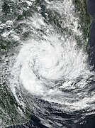
 7 March: Freddy intensifying off the coast of Madagascar.
 -
 11 March: Freddy nearly stationary while off the coast of Mozambique.
 -
 12 March: Freddy weakening after its second landfall in Mozambique while delivering flooding rains.


Records
Cyclone Freddy holds the record for the longest-lasting tropical cyclone worldwide in recorded history, [2] [88] pending a formal investigation to be conducted by the World Meteorological Organization (WMO), in order to determine whether Freddy truly tied or surpassed John's record. [89] Freddy also holds the record for the all-time highest accumulated cyclone energy of a tropical cyclone worldwide, with an ACE of 87.01, breaking the former record of 85.26, set by Ioke in 2006. [1] Additionally, Freddy was the first tropical cyclone to undergo seven separate rounds of rapid intensification. [1] No other tropical cyclone in the Southern Hemisphere is known to have rapidly intensified more than three times. [90] Only three other storms, all in the Northern Hemisphere, underwent four periods of rapid intensification, namely Norman in 2018, Emily in 2005, and Hurricane |John in 1994. [2] Freddy was one of only four systems—the others being cyclones Litanne in 1994 and Leon–Eline and Hudah in 2000—to travel the entirety of the southern Indian Ocean. [91]
See also
- List of South-West Indian Ocean very intense tropical cyclones
- List of Category 4 Australian region severe tropical cyclones
- Tropical cyclones in the Mascarene Islands
- Hurricane John (1994) – The second longest-lasting and the farthest-traveling tropical cyclone ever observed
- Cyclones Katrina and Victor–Cindy (1998) – An extremely long-lived tropical cyclone in the South Pacific that eventually regenerated into another cyclone in the Indian Ocean
- Hurricanes Dora in 1999 and in 2023 – Both tracked across all three north Pacific basins
- Hurricane Ioke (2006) – The second highest accumulated cyclone energy (ACE) recorded in history
Notes
- ^ The Joint Typhoon Warning Center is a joint United States Navy – United States Air Force task force that issues tropical cyclone warnings for the Indian Ocean and other regions. [6]
- ^ The Tropical Cyclone Warning Centre in Melbourne, Australia, is a branch of the country's Bureau of Meteorology, which is the official Regional Specialized Meteorological Center for the Australian basin. [9]
- ^ Météo-France's meteorological office in Réunion (MFR) is the official Regional Specialized Meteorological Center for the South-West Indian Ocean, tracking all tropical cyclones south of the equator, from the east coast of Africa to 90° E. [27]
References
- ^ a b c d Cappucci, Matthew (12 March 2023). "Lashing Mozambique, Freddy has become Earth's most energetic cyclone on record". Washington Post. ISSN 0190-8286. Archived from the original on 13 March 2023. Retrieved 13 March 2023.
- ^ a b c Cappucci, Matthew (7 March 2023). "Deadly cyclone Freddy has become Earth's longest-lived tropical storm". The Washington Post. Archived from the original on 7 March 2023. Retrieved 7 March 2023.
- ^ Clegg, Pete; Craig, Earl-Spurr; Paterson, Linda (17 June 2022). Severe Tropical Cyclone Freddy (PDF) (Report). Tropical Cyclone Report. Perth, Western Australia: Bureau of Meteorology. Retrieved 19 July 2023.
- ^ a b c Tropical Cyclone Report: Severe Tropical Cyclone Freddy (Report). Australian Bureau of Meteorology. Archived from the original on 23 March 2023. Retrieved 1 April 2023.
- ^ Tropical Cyclone Outlook for the Western Region Issued at 2:00 pm WST on Monday 30 January 2023 for the period until midnight WST Thursday 2 February 2023 (Report). Australian Bureau of Meteorology. 30 January 2023. Archived from the original on 3 February 2023. Retrieved 6 February 2023.
- ^ Frequently Asked Questions (Report). Joint Typhoon Warning Center. 13 August 2012. Archived from the original on 4 October 2013. Retrieved 22 September 2012.
- ^ Tropical Cyclone Formation Alert (Invest 97S) (Report). United States Joint Typhoon Warning Center. 6 February 2023. Retrieved 6 February 2023.[ dead link] Alt URL
- ^ Tropical Cyclone 11S (Eleven) Warning No. 1 (Report). United States Joint Typhoon Warning Center. 6 February 2023. Archived from the original on 7 January 2023. Retrieved 6 February 2023. Alt URL
- ^ Worldwide Tropical Cyclone Centers (Report). National Hurricane Center. 11 September 2011. Archived from the original on 21 March 2015. Retrieved 27 August 2012.
- ^ Tropical Cyclone Forecast Track Map for Tropical Cyclone Freddy (Report). Australian Bureau of Meteorology. 6 February 2023. Archived from the original on 6 February 2023. Retrieved 6 February 2023.
- ^ Tropical Cyclone Technical Bulletin (Western Region) (Report). Australian Bureau of Meteorology. 6 February 2023. Archived from the original on 6 February 2023. Retrieved 6 February 2023.
- ^ Prognostic Reasoning for Tropical Cyclone 11S (Freddy) Warning No. 4 (Report). United States Joint Typhoon Warning Center. 7 February 2023. Archived from the original on 7 February 2023. Retrieved 7 February 2023. Alt URL
- ^ "Tropical Cyclone Forecast Track Map for Tropical Cyclone Freddy". Australian Bureau of Meteorology. 7 February 2023. Archived from the original on 7 February 2023. Retrieved 7 February 2023.
- ^ "Tropical Cyclone Technical Bulletin (Western Region)". Australian Bureau of Meteorology. 7 February 2023. Archived from the original on 7 February 2023. Retrieved 7 February 2023.
- ^ Prognostic Reasoning for Tropical Cyclone 11S (Freddy) Warning No. 6 (Report). United States Joint Typhoon Warning Center. 7 February 2023. Archived from the original on 7 February 2023. Retrieved 7 February 2023. Alt URL
- ^ Prognostic Reasoning for Tropical Cyclone 11S (Freddy) Warning No. 8 (Report). United States Joint Typhoon Warning Center. 8 February 2023. Archived from the original on 8 February 2023. Retrieved 8 February 2023.
- ^ Prognostic Reasoning for Tropical Cyclone 11S (Freddy) Warning No. 10 (Report). United States Joint Typhoon Warning Center. 8 February 2023. Archived from the original on 9 February 2023. Retrieved 8 February 2023.
- ^ "Tropical Cyclone Technical Bulletin (Western Region)". Australian Bureau of Meteorology. 9 February 2023. Archived from the original on 9 February 2023. Retrieved 9 February 2023.
- ^ Prognostic Reasoning for Tropical Cyclone 11S (Freddy) Warning No. 13 (Report). United States Joint Typhoon Warning Center. 9 February 2023. Archived from the original on 9 February 2023. Retrieved 9 February 2023.
- ^ Prognostic Reasoning for Tropical Cyclone 11S (Freddy) Warning No. 18 (Report). United States Joint Typhoon Warning Center. 11 February 2023. Archived from the original on 11 February 2023. Retrieved 11 February 2023.
- ^ "Tropical Cyclone Technical Bulletin (Western Region)". Australian Bureau of Meteorology. 11 February 2023. Archived from the original on 11 February 2023. Retrieved 11 February 2023.
- ^ Prognostic Reasoning for Tropical Cyclone 11S (Freddy) Warning No. 19 (Report). United States Joint Typhoon Warning Center. 12 February 2023. Archived from the original on 12 February 2023. Retrieved 12 February 2023. Alt URL
- ^ Prognostic Reasoning for Tropical Cyclone 11S (Freddy) Warning No. 20 (Report). United States Joint Typhoon Warning Center. 12 February 2023. Archived from the original on 12 February 2023. Retrieved 12 February 2023.
- ^ "Tropical Cyclone Technical Bulletin (Western Region)". Australian Bureau of Meteorology. 12 February 2023. Archived from the original on 13 February 2023. Retrieved 13 February 2023.
- ^ Prognostic Reasoning for Tropical Cyclone 11S (Freddy) Warning No. 22 (Report). United States Joint Typhoon Warning Center. 13 February 2023. Archived from the original on 15 February 2023. Retrieved 13 February 2023.
- ^ Prognostic Reasoning for Tropical Cyclone 11S (Freddy) Warning No. 23 (Report). United States Joint Typhoon Warning Center. 14 February 2023. Archived from the original on 15 February 2023. Retrieved 14 February 2023.
- ^ RA I Tropical Cyclone Committee (2023). Tropical Cyclone Operational Plan for the South-West Indian Ocean (PDF) (Report). World Meteorological Organization.
- ^ Tropical Cyclone 07 (Freddy) Warning Number (1/7/20222023) (PDF) (Report). Météo-France. 14 February 2023. Archived from the original (PDF) on 15 February 2023. Retrieved 14 February 2023.
- ^ "Tropical Cyclone Forecast Track Map for Severe Tropical Cyclone Freddy (13U)". Australian Bureau of Meteorology. 14 February 2023. Archived from the original on 14 February 2023. Retrieved 14 February 2023.
- ^ Intense Tropical Cyclone 07 (Freddy) Warning Number (2/7/20222023) (PDF) (Report). Météo-France. 14 February 2023. Archived from the original (PDF) on 15 February 2023. Retrieved 14 February 2023.
- ^ Tropical Cyclone 11S (Freddy) Warning No. 25 (Report). United States Joint Typhoon Warning Center. 12 February 2023. Archived from the original on 9 February 2023. Retrieved 12 February 2023. Alt URL
- ^ Cappucci, Matthew. "Cyclone Freddy teeters on brink of Category 5 strength in Indian Ocean". Washington Post. ISSN 0190-8286. Archived from the original on 17 February 2023. Retrieved 17 February 2023.
- ^ "JTWC Best Track on Tropical Cyclone Freddy (11S)". National Oceanic and Atmospheric Administration. Archived from the original on 6 February 2023. Retrieved 17 February 2023.
- ^ Tropical Cyclone 11S (Freddy) Warning No. 29 (Report). United States Joint Typhoon Warning Center. 17 February 2023. Archived from the original on 17 February 2023. Retrieved 17 February 2023.
- ^ Prognostic Reasoning for Tropical Cyclone 11S (Freddy) Warning No. 31 (Report). United States Joint Typhoon Warning Center. 18 February 2023. Archived from the original on 18 February 2023. Retrieved 18 February 2023.
- ^ Tropical Cyclone 11S (Freddy) Warning No. 32 (Report). United States Joint Typhoon Warning Center. 18 February 2023. Archived from the original on 9 February 2023. Retrieved 18 February 2023. Alt URL
- ^ Very Intense Tropical Cyclone 07 (Freddy) Warning Number (19/7/20222023) (PDF) (Report). Météo-France. 19 February 2023. Archived from the original (PDF) on 19 February 2023. Retrieved 19 February 2023.
- ^ Intense Tropical Cyclone 07 (Freddy) Warning Number (23/7/20222023) (PDF) (Report). Météo-France. 20 February 2023. Archived (PDF) from the original on 21 February 2023. Retrieved 20 February 2023.
- ^ Prognostic Reasoning for Tropical Cyclone 11S (Freddy) Warning No. 36 (Report). United States Joint Typhoon Warning Center. 20 February 2023. Archived from the original on 6 February 2023. Retrieved 20 February 2023. Alt URL
- ^ Tropical Cyclone 07 (Freddy) Warning Number (28/7/20222023) (PDF) (Report). Météo-France. 21 February 2023. Archived (PDF) from the original on 21 February 2023. Retrieved 21 February 2023.
- ^ "Cyclone Freddy Moving Across Madagascar, Then A Flood Danger For Mozambique". www.wunderground.com. Archived from the original on 22 February 2023. Retrieved 22 February 2023.
- ^ Overland Depression 07 (Freddy) Warning Number (30/7/20222023) (PDF) (Report). Météo-France. 21 February 2023. Archived (PDF) from the original on 22 February 2023. Retrieved 21 February 2023.
- ^ Prognostic Reasoning for Tropical Cyclone 11S (Freddy) Warning No. 39 (Report). United States Joint Typhoon Warning Center. 22 February 2023. Archived from the original on 6 February 2023. Retrieved 22 February 2023. Alt URL
- ^ a b Zone of Disturbed Weather 07 (Freddy) Warning Number (33/7/20222023) (PDF) (Report). Météo-France. 22 February 2023. Archived (PDF) from the original on 23 February 2023. Retrieved 23 February 2023.
- ^ Prognostic Reasoning for Tropical Cyclone 11S (Freddy) Warning No. 40 (Report). United States Joint Typhoon Warning Center. 22 February 2023. Archived from the original on 6 February 2023. Retrieved 22 February 2023. Alt URL
- ^ Prognostic Reasoning for Tropical Cyclone 11S (Freddy) Warning No. 41 (Report). United States Joint Typhoon Warning Center. 23 February 2023. Archived from the original on 6 February 2023. Retrieved 23 February 2023. Alt URL
- ^ Moderate Tropical Storm 07 (Freddy) Warning Number (36/7/20222023) (PDF) (Report). Météo-France. 23 February 2023. Archived (PDF) from the original on 23 February 2023. Retrieved 23 February 2023.
- ^ Prognostic Reasoning for Tropical Cyclone 11S (Freddy) Warning No. 42 (Report). United States Joint Typhoon Warning Center. 23 February 2023. Archived from the original on 23 February 2023. Retrieved 23 February 2023.
- ^ Severe Tropical Storm 07 (Freddy) Warning Number (37/7/20222023) (PDF) (Report). Météo-France. 23 February 2023. Archived (PDF) from the original on 24 February 2023. Retrieved 23 February 2023.
- ^ Severe Tropical Storm 07 (Freddy) Warning Number (39/7/20222023) (PDF) (Report). Météo-France. 24 February 2023. Archived (PDF) from the original on 24 February 2023. Retrieved 24 February 2023.
- ^ Severe Tropical Storm 07 (Freddy) Warning Number (40/7/20222023) (PDF) (Report). Météo-France. 24 February 2023. Archived (PDF) from the original on 24 February 2023. Retrieved 24 February 2023.
- ^ Moderate Tropical Storm 07 (Freddy) Warning Number (41/7/20222023) (PDF) (Report). Météo-France. 24 February 2023. Archived (PDF) from the original on 24 February 2023. Retrieved 24 February 2023.
- ^ Tropical Cyclone 11S (Freddy) Warning No. 44 (Report). United States Joint Typhoon Warning Center. 24 February 2023. Archived from the original on 24 February 2023. Retrieved 24 February 2023.
- ^ Overland Depression 07 (Freddy) Warning Number (42/7/20222023) (PDF) (Report). Météo-France. 24 February 2023. Archived (PDF) from the original on 24 February 2023. Retrieved 24 February 2023.
- ^ Overland Depression 07 (Freddy) Warning Number (44/7/20222023) (PDF) (Report). Météo-France. 25 February 2023. Archived (PDF) from the original on 25 February 2023. Retrieved 25 February 2023.
- ^ Overland Depression 07 (Freddy) Warning Number (45/7/20222023) (PDF) (Report). Météo-France. 25 February 2023. Archived (PDF) from the original on 26 February 2023. Retrieved 25 February 2023.
- ^ Bulletin for Cyclonic Activity and Significant Tropical Weather in the Southwest Indian Ocean (PDF) (Report). Météo-France. 28 February 2023. Archived (PDF) from the original on 1 March 2023. Retrieved 28 February 2023.
- ^ a b Significant Tropical Weather Advisory for the Indian Ocean, 18Z 2 March 2023 (Report). United States Joint Typhoon Warning Center. 2 March 2023. Archived from the original on 2 March 2023. Retrieved 2 March 2023.
- ^ Tropical Disturbance 07 (Freddy) Warning Number (46/7/20222023) (PDF) (Report). Météo-France. 2 March 2023. Archived (PDF) from the original on 2 March 2023. Retrieved 2 March 2023.
- ^ Significant Tropical Weather Advisory for the Indian Ocean, 03Z 3 March 2023 (Report). United States Joint Typhoon Warning Center. 3 March 2023. Archived from the original on 3 March 2023. Retrieved 3 March 2023.
- ^ Zone of Disturbed Weather 07 (Freddy) Warning Number (47/7/20222023) (PDF) (Report). Météo-France. 3 March 2023. Archived (PDF) from the original on 3 March 2023. Retrieved 3 March 2023.
- ^ a b Tropical Cyclone Formation Alert (Invest 11S) (Report). United States Joint Typhoon Warning Center. 3 March 2023. Archived from the original on 4 March 2023. Retrieved 3 March 2023.
- ^ Tropical Depression 07 (Freddy) Warning Number (50/7/20222023) (PDF) (Report). Météo-France. 4 March 2023. Archived (PDF) from the original on 3 March 2023. Retrieved 4 March 2023.
- ^ Moderate Tropical Storm 07 (Freddy) Warning Number (51/7/20222023) (PDF) (Report). Météo-France. 4 March 2023. Archived (PDF) from the original on 4 March 2023. Retrieved 4 March 2023.
- ^ Prognostic Reasoning for Tropical Cyclone 11S (Freddy) Warning No. 45 (Report). United States Joint Typhoon Warning Center. 4 March 2023. Archived from the original on 4 March 2023. Retrieved 4 March 2023.
- ^ Moderate Tropical Storm 07 (Freddy) Warning Number (55/7/20222023) (PDF) (Report). Météo-France. 5 March 2023. Archived (PDF) from the original on 5 March 2023. Retrieved 5 March 2023.
- ^ Moderate Tropical Storm 07 (Freddy) Warning Number (56/7/20222023) (PDF) (Report). Météo-France. 5 March 2023. Archived (PDF) from the original on 5 March 2023. Retrieved 5 March 2023.
- ^ Severe Tropical Storm 07 (Freddy) Warning Number (57/7/20222023) (PDF) (Report). Météo-France. 5 March 2023. Archived (PDF) from the original on 5 March 2023. Retrieved 5 March 2023.
- ^ Prognostic Reasoning for Tropical Cyclone 11S (Freddy) Warning No. 50 (Report). United States Joint Typhoon Warning Center. 7 March 2023. Archived from the original on 7 March 2023. Retrieved 7 March 2023.
- ^ Severe Tropical Storm 07 (Freddy) Warning Number (63/7/20222023) (PDF) (Report). Météo-France. 7 March 2023. Archived (PDF) from the original on 7 March 2023. Retrieved 7 March 2023.
- ^ Tropical Cyclone 07 (Freddy) Warning Number (64/7/20222023) (PDF) (Report). Météo-France. 7 March 2023. Archived (PDF) from the original on 7 March 2023. Retrieved 7 March 2023.
- ^ Prognostic Reasoning for Tropical Cyclone 11S (Freddy) Warning No. 51 (Report). United States Joint Typhoon Warning Center. 7 March 2023. Archived from the original on 7 February 2023. Retrieved 7 March 2023. Alt URL
- ^ Tropical Cyclone 07 (Freddy) Warning Number (68/7/20222023) (PDF) (Report). Météo-France. 8 March 2023. Archived (PDF) from the original on 8 March 2023. Retrieved 8 March 2023.
- ^ Severe Tropical Storm 07 (Freddy) Warning Number (69/7/20222023) (PDF) (Report). Météo-France. 8 March 2023. Archived (PDF) from the original on 8 March 2023. Retrieved 8 March 2023.
- ^ a b Prognostic Reasoning for Tropical Cyclone 11S (Freddy) Warning No. 54 (Report). United States Joint Typhoon Warning Center. 9 March 2023. Archived from the original on 9 March 2023. Retrieved 9 March 2023.
- ^ Severe Tropical Storm 07 (Freddy) Warning Number (71/7/20222023) (PDF) (Report). Météo-France. 8 March 2023. Archived (PDF) from the original on 9 March 2023. Retrieved 9 March 2023.
- ^ Prognostic Reasoning for Tropical Cyclone 11S (Freddy) Warning No. 56 (Report). United States Joint Typhoon Warning Center. 10 March 2023. Archived from the original on 10 March 2023. Retrieved 10 March 2023.
- ^ Tropical Cyclone 07 (Freddy) Warning Number (73/7/20222023) (PDF) (Report). Météo-France. 9 March 2023. Archived (PDF) from the original on 9 March 2023. Retrieved 9 March 2023.
- ^ Tropical Cyclone 07 (Freddy) Warning Number (78/7/20222023) (PDF) (Report). Météo-France. 11 March 2023. Archived (PDF) from the original on 11 March 2023. Retrieved 11 March 2023.
- ^ Prognostic Reasoning for Tropical Cyclone 11S (Freddy) Warning No. 59 (Report). United States Joint Typhoon Warning Center. 11 March 2023. Archived from the original on 11 March 2023. Retrieved 11 March 2023.
- ^ "Mozambique: Severe Tropical Storm Freddy - Flash Update No.8 (as of 11 March 2023) - Mozambique | ReliefWeb". reliefweb.int. 11 March 2023. Archived from the original on 12 March 2023. Retrieved 12 March 2023.
- ^ Tropical Cyclone 07 (Freddy) Warning Number (81/7/20222023) (PDF) (Report). Météo-France. 11 March 2023. Archived (PDF) from the original on 12 March 2023. Retrieved 11 March 2023.
- ^ Tropical Cyclone 11S (Freddy) Warning No. 60 (Report). United States Joint Typhoon Warning Center. 12 March 2023. Archived from the original on 12 March 2023. Retrieved 12 March 2023.
- ^ Severe Tropical Storm 07 (Freddy) Warning Number (83/7/20222023) (PDF) (Report). Météo-France. 12 March 2023. Archived (PDF) from the original on 12 March 2023. Retrieved 12 March 2023.
- ^ Moderate Tropical Storm 07 (Freddy) Warning Number (84/7/20222023) (PDF) (Report). Météo-France. 12 March 2023. Archived (PDF) from the original on 12 March 2023. Retrieved 12 March 2023.
- ^ Overland Depression 07 (Freddy) Warning Number (85/7/20222023) (PDF) (Report). Météo-France. 12 March 2023. Archived (PDF) from the original on 13 March 2023. Retrieved 12 March 2023.
- ^ "Best Track Data on Very Intense Tropical Cyclone Freddy (07)". Météo-France. Archived from the original on 13 March 2023. Retrieved 15 March 2023.
- ^ SVS (16 March 2023). "NASA Scientific Visualization Studio - NASA Tracks Freddy, Longest-lived Tropical Cyclone on Record". SVS. Retrieved 18 March 2023.
- ^ Donegan, Brian (6 March 2023). "Freddy likely to set new world record for longest-lasting tropical cyclone as it heads for Mozambique again". FOX Weather. Archived from the original on 7 March 2023. Retrieved 8 March 2023.
- ^ "Tropical Cyclone Freddy may set new record". public.wmo.int. 7 March 2023. Retrieved 8 March 2023.
- ^ "Tropical Cyclone Freddy Breaks Records before Lashing Madagascar". National Environmental Satellite, Data, and Information Service. Archived from the original on 26 February 2023. Retrieved 26 February 2023.
External links
Wikimedia Commons has media related to
Cyclone Freddy.
- Tropical Cyclone Report; Severe Tropical Cyclone Freddy from the Bureau of Meteorology
- MFR Track Data of Very Intense Tropical Cyclone Freddy (in French)
- JTWC Operational Track Data of Tropical Cyclone 11S (Freddy)
- 11S.FREDDY from the United States Naval Research Laboratory
Tropical cyclones of the
2022–23 Australian region cyclone season | ||
|---|---|---|
 | ||
Tropical cyclones of the
2022–23 South-West Indian Ocean cyclone season | ||
|---|---|---|
 | ||