Merhav Am
מֶרְחַב עַם | |
|---|---|
 | |
| Etymology: Nation's Expanse | |
| Coordinates: 30°53′14″N 34°49′44″E / 30.88722°N 34.82889°E | |
| Country | |
| District | Southern |
| Council | Ramat HaNegev |
| Founded | 2001 |
| Founded by | Or Movement |
| Population (2022)
[1] | 516 |
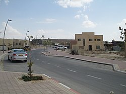
Merhav Am ( Hebrew: מֶרְחַב עַם, lit. 'Nation's Expanse') is a religious community settlement in southern Israel. Located in the Negev desert between Yeruham and the kibbutz of Sde Boker, it falls under the jurisdiction of Ramat HaNegev Regional Council. In 2022 it had a population of 516. [1]
History
Merhav Am was founded by the Or Movement on 1 November 2001 and had a population of around 30 families by November 2006, many living in mobile homes.
The original name was intended to be Halukim due to its proximity to the Halukim Hills (the nearest road junction is called Halukim Junction). However, after around a year it was renamed Merhav Am, inspired by the wide open area in which it was to be built, as well as in honour of Rehavam Ze'evi, a former Minister who was assassinated in 2001: In Hebrew Merhav (מרחב - MRHV) means "wide open spaces" whilst Rehavam is spelt using the last three letters of the word plus two more (רחבעם - RHVAM). Combining the two gives Merhav Am (MRHV+AM).
References
- ^ a b "Regional Statistics". Israel Central Bureau of Statistics. Retrieved 21 March 2024.
External links
- Official website (in Hebrew)

