-
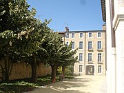 Marron Hotel
 -
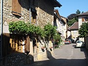 Old street
You can help expand this article with text translated from
the corresponding article in French. (December 2008) Click [show] for important translation instructions.
|
Meillonnas | |
|---|---|
Commune | |
 Town hall | |
 Coat of arms | |
 Meillonnas  Meillonnas | |
| Coordinates: 46°14′45″N 5°21′09″E / 46.2458°N 5.3525°E | |
| Country | France |
| Region | Auvergne-Rhône-Alpes |
| Department | Ain |
| Arrondissement | Bourg-en-Bresse |
| Canton | Saint-Étienne-du-Bois |
| Intercommunality | CA Bassin de Bourg-en-Bresse |
| Government | |
| • Mayor (2020–2026) | Jean-Pierre Arragon [1] |
| Area 1 | 17.74 km2 (6.85 sq mi) |
| Population (2021)
[2] | 1,383 |
| • Density | 78/km2 (200/sq mi) |
| Time zone | UTC+01:00 ( CET) |
| • Summer ( DST) | UTC+02:00 ( CEST) |
| INSEE/Postal code |
01241 /01370 |
| Elevation | 232–460 m (761–1,509 ft) (avg. 279 m or 915 ft) |
| 1 French Land Register data, which excludes lakes, ponds, glaciers > 1 km2 (0.386 sq mi or 247 acres) and river estuaries. | |
Meillonnas (French pronunciation: [mɛjɔna]) is a commune in the Ain department in eastern France.
Geography
The Sevron has its source in the commune; it crosses the village and forms part of the commune's northern border.
The bief du Bois Tharlet, a tributary of the Sevron, forms most of the commune's western border.
Population
| Year | Pop. | ±% p.a. |
|---|---|---|
| 1968 | 630 | — |
| 1975 | 671 | +0.90% |
| 1982 | 891 | +4.13% |
| 1990 | 1,051 | +2.09% |
| 1999 | 1,204 | +1.52% |
| 2009 | 1,301 | +0.78% |
| 2014 | 1,310 | +0.14% |
| 2020 | 1,379 | +0.86% |
| Source: INSEE [3] | ||


See also
References
- ^ "Répertoire national des élus: les maires" (in French). data.gouv.fr, Plateforme ouverte des données publiques françaises. 13 September 2022.
- ^ "Populations légales 2021". The National Institute of Statistics and Economic Studies. 28 December 2023.
- ^ Population en historique depuis 1968, INSEE
External links
-
 Media related to
Meillonnas at Wikimedia Commons
Media related to
Meillonnas at Wikimedia Commons
| International | |
|---|---|
| National | |
|
| This Ain geographical article is a stub. You can help Wikipedia by expanding it. |