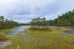
| Meenikunno Nature Reserve | |
|---|---|
 | |
| Location | Estonia |
| Coordinates | 57°56′30″N 27°19′00″E / 57.9417°N 27.3167°E |
| Area | 3028 ha |
| Established | 1981 (2015) |
Meenikunno Nature Reserve is a nature reserve which is located on the border of Põlva County and Võru County in Estonia. [1]
The area of the nature reserve is 3028 ha. [2]
The protected area was founded in 1981 on the basis of Meenikunno Wetland Conservation Area. Before 2015, there existed Meenikunno Landscape Conservation Area. [1]

References
- ^ a b "Meenikunno looduskaitseala kaitse-eeskiri – Riigi Teataja". www.riigiteataja.ee. Retrieved 5 April 2021.
- ^ "Meenikunno Looduskaitseala". Protected Planet. Retrieved 2 April 2021.
