 Part of Medusae Fossae, from a
THEMIS day-time image | |
| Coordinates | 3°12′S 163°00′W / 3.2°S 163.0°W |
|---|---|
| Length | 5,000 km |
The Medusae Fossae Formation is a large geological formation of probable volcanic origin on the planet Mars. [1] It is named for the Medusa of Greek mythology. "Fossae" is Latin for "trenches". The formation is a collection of soft, easily eroded deposits that extends discontinuously for more than 5,000 km along the equator of Mars. Its roughly-shaped regions extend from just south of Olympus Mons to Apollinaris Patera, with a smaller additional region closer to Gale Crater. [2]
The total area of the formation is equal to 20% the size of the continental United States. [3] It is divided into three subunits (members) that are all considered to be of Amazonian age, the youngest era in martian geological history. [4] The formation straddles the highland - lowland boundary near the Tharsis and Elysium volcanic areas, and extends across five quadrangles: Amazonis, Tharsis, Memnonia, Elysium, and Aeolis.
Origin and age
The origin of the formation is unknown, but many theories have been presented over the years. In 2020, a group of researchers headed by Peter Mouginis-Mark has hypothesized that the formation could have been formed from pumice rafts from the volcano Olympus Mons. [5] In 2012, a group headed by Laura Kerber hypothesized that it could have been formed from ash from the volcanoes Apollinaris Mons, Arsia Mons, and possibly Pavonis Mons. [6]
An analysis of data from the Mars Odyssey Neutron Spectrometer revealed that the western lobe of the Medusae Fossae Formation contains some water. This means that this formation contains bulk water ice. During periods of high obliquity (tilt) water ice was stable on the surface. [7] By means of a re-analysis of data from Mars Express' MARSIS radar, Thomas Watters found evidence about the existence of large underground water deposits in Medusae Fossae up to 3.7 km thick and covered by hundreds of meters of dust. [8]
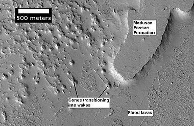
Combining several gravity models of Mars with the MOLA topographic dataset allowed calculation of the density of the deposit; the value is 1.765 ± 0.105 g/cm3, similar to the density of terrestrial ignimbrites. [9] This rules out significant amounts of ice in the bulk composition. In combination with the deposit's high content of sulfur and chlorine, it implies an explosive volcanic origin. The total volume of the deposit is 1.4 × 10⁶ km3; such a large deposit might have been emplaced in periodic eruptions over an interval of 500 million years. [9]
Appearance and composition
In some places, the formation appears as a smooth and gently undulating surface, while in others it is wind-sculpted into ridges and grooves. [1] Radar imaging has suggested that the region may contain either extremely porous rock (for example volcanic ash) or deep layers of glacier-like ice deposits amounting to about the same quantity as is stored in Mars' south polar cap. [10] [11] Further evidence for a fine-grained composition is the fact that the area gives almost no radar return.
-
 Plateau and rootless cones (HiRISE)
 -
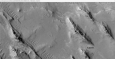
 Mounds with layers, east of Gale Crater in Aeolis quadrangle
 -
 Layers and mounds, east of Gale Crater
 -
 Layers and a field of small mounds, east of Gale Crater
 -
 Mound showing layers at the base, east of Gale Crater
 -
 Surface features along a scarp in Memnonia quadrangle (HiRISE)


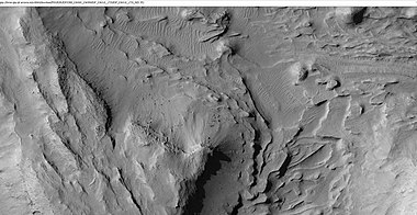
Inverted relief

The lower portion (member) of Medusae Fossae Formation contains many patterns and shapes that are thought to be the remains of streams. It is believed that streams formed valleys that were filled and became resistant to erosion by cementation of minerals or by the gathering of a coarse covering layer to form an inverted relief. These inverted stream beds are sometimes called sinuous ridges or raised curvilinear features. They have been divided into six classes: flat-crested, narrow-crested, round-crested, branching, non-branching, and multilevel. They may be a kilometer or so in length. Their height ranges from a meter to greater than 10 meters, while the width of the narrow ones is less than 10 meters. [12]
Yardangs and dust
Comparisons of elemental composition suggest that the Medusae Fossae Formation has been a source of Mars' ubiquitous surface dust. [3] In July 2018, researchers reported that it may be the largest single source of dust on the planet. [3]
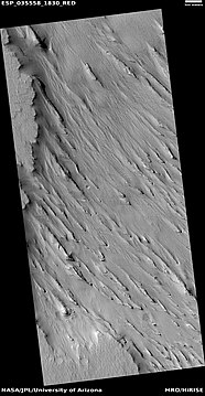
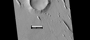
The surface of the formation has been eroded by the wind into a series of linear ridges called yardangs. [13] These ridges generally point in direction of the prevailing winds that carved them, and demonstrate the erosive power of Martian winds. The easily eroded nature of the Medusae Fossae Formation suggests that it is composed of weakly cemented particles, and was most likely formed by the deposition of wind-blown dust or volcanic ash. Yardangs are parts of rock that have been sand blasted into long, skinny ridges by bouncing sand particles blowing in the wind. [14] Layers are seen in parts of the formation. A resistant caprock on the top of yardangs has been observed in Viking, [15] Mars Global Surveyor, [16] and HiRISE photos. [17] Images from spacecraft show that they have different degrees of hardness probably because of significant variations in the physical properties, composition, particle size, and/or cementation. Very few impact craters are visible throughout the area so the surface is relatively young. [18]
-
 Yardangs in the Medusae Fossae ( THEMIS)
 -

-
 Yardangs in Arsinoes Chaos (HiRISE)
 -
 Close-up, arrows point to transverse aeolian sand ridges (HiRISE)
 -
 Yardangs in Amazonis (HiRISE)
 -
 Yardangs with caprock labeled, in Aeolis (HiRISE)
 -
 Yardangs near Gordii Dorsum, in the north of the formation (HiRISE)
 -
 Yardangs near Gordii Dorsum (enlargement of the previous image)
 -
 Yardangs near Gordii Dorsum (enlargement of the previous image)
 -
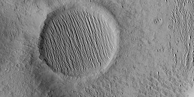
 Yardangs near a crater in Amazonis, in the middle of the region
 -
 Yardangs showing layers, east of Gale Crater in Aeolis (HiRISE)
 -
 Yardangs, in a crater in Amazonis quadrangle (HiRISE)


See also
- Aeolis quadrangle
- Amazonis Planitia
- Amazonis quadrangle
- Geology of Mars
- Groundwater on Mars
- Impact crater
- Yardangs on Mars
External links
- Graphical image of the geographical extent of the Medusae Fossae Formation, Nature Communications
References
- ^ a b "The Medusa Fossae formation on Mars". European Space Agency. 29 March 2005.
- ^ Lujendra Ojha; Kevin Lewis; Suniti Karunatillake; Mariek Schmidt (July 20, 2018). "Fig. 1, The Medusae Fossae Formation as the single largest source of dust on Mars". Nature Communications. ISSN 2041-1723.
- ^ a b c Ojha, Lujendra; Lewis, Kevin; Karunatillake, Suniti; Schmidt, Mariek (2018). "The Medusae Fossae Formation as the single largest source of dust on Mars". Nature Communications. 9 (1): 2867. Bibcode: 2018NatCo...9.2867O. doi: 10.1038/s41467-018-05291-5. PMC 6054634. PMID 30030425.
- ^ Greeley, Ronald; Guest, J.E. (1987). Geologic map of the eastern equatorial region of Mars. U.S. Geological Survey (Report). CiteSeerX 10.1.1.457.7583. doi: 10.3133/i1802B.
- ^ "Scientists Float a New Theory on the Medusae Fossae Formation". Eos. 19 May 2020. Retrieved 2021-06-26.
- ^ Kerber, Laura; Head, James W.; Madeleine, Jean-Baptiste; Forget, François; Wilson, Lionel (2012). "The dispersal of pyroclasts from ancient explosive volcanoes on Mars: Implications for the friable layered deposits". Icarus. 219 (1): 358–381. Bibcode: 2012Icar..219..358K. doi: 10.1016/j.icarus.2012.03.016.
- ^ Wilson, Jack T.; Eke, Vincent R.; Massey, Richard J.; Elphic, Richard C.; Feldman, William C.; Maurice, Sylvestre; Teodoro, Luís F.A. (2018). "Equatorial locations of water on Mars: Improved resolution maps based on Mars Odyssey Neutron Spectrometer data". Icarus. 299: 148–160. arXiv: 1708.00518. Bibcode: 2018Icar..299..148W. doi: 10.1016/j.icarus.2017.07.028. S2CID 59520156.
- ^ "Buried water ice at Mars's equator?". European Space Agency. 18 January 2024. Retrieved 19 January 2024.
- ^ a b Ojha, Lujendra; Lewis, Kevin (2018). "The Density of the Medusae Fossae Formation: Implications for its Composition, Origin, and Importance in Martian History". Journal of Geophysical Research: Planets. 123 (6): 1368–1379. Bibcode: 2018JGRE..123.1368O. doi: 10.1029/2018JE005565.
-
^ Watters, T. R.; Campbell, B.; Carter, L.; Leuschen, C. J.; Plaut, J. J.; Picardi, G.; Orosei, R.; Safaeinili, A.; Clifford, S. M.; Farrell, W. M.; Ivanov, A. B.; Phillips, R. J.; Stofan, E. R. (2007).
"Radar Sounding of the Medusae Fossae Formation Mars: Equatorial Ice or Dry, Low-Density Deposits?". Science. 318 (5853): 1125–1128.
Bibcode:
2007Sci...318.1125W.
doi:
10.1126/science.1148112.
PMID
17975034.
S2CID
25050428.
- David Shiga (November 1, 2007). "Vast amount of water ice may lie on Martian equator". NewScientist.
- ^ Orosei, R.; Cantini, F.; Caprarelli, G.; Carter, L. M.; Papiano, I.; Rossi, A. P. (2016). "Radar Sounding by MARSIS over Lucus Planum, Mars". Lunar and Planetary Science Conference (1903): 1869. Bibcode: 2016LPI....47.1869O.
- ^ Zimbelman, James R.; Griffin, Lora J. (2010). "HiRISE images of yardangs and sinuous ridges in the lower member of the Medusae Fossae Formation, Mars". Icarus. 205 (1): 198–210. Bibcode: 2010Icar..205..198Z. doi: 10.1016/j.icarus.2009.04.003.
- ^ Bridges, Nathan T.; Muhs, Daniel R. (2012). "Duststones on Mars: Source, Transport, Deposition, and Erosion". Sedimentary Geology of Mars. pp. 169–182. doi: 10.2110/pec.12.102.0169. ISBN 978-1-56576-312-8.
- ^ "HiRISE | Yardangs in Arsinoes Chaos (ESP_039563_1730)".
- ^ Scott, David H.; Tanaka, Kenneth L. (1982). "Ignimbrites of Amazonis Planitia Region of Mars". Journal of Geophysical Research: Solid Earth. 87: 1179–1190. Bibcode: 1982JGR....87.1179S. doi: 10.1029/JB087iB02p01179.
- ^ Malin, M. C.; Carr, M. H.; Danielson, G. E.; Davies, M. E.; Hartmann, W. K.; Ingersoll, A. P.; James, P. B.; Masursky, H.; McEwen, A. S.; Soderblom, L. A.; Thomas, P.; Veverka, J.; Caplinger, M. A.; Ravine, M. A.; Soulanille, T. A.; Warr En, J. L. (1998). "Early Views of the Martian Surface from the Mars Orbiter Camera of Mars Global Surveyor". Science. 279 (5357): 1681–1685. Bibcode: 1998Sci...279.1681M. doi: 10.1126/science.279.5357.1681. PMID 9497280.
- ^ Mandt, Kathleen E.; De Silva, Shanaka L.; Zimbelman, James R.; Crown, David A. (2008). "Origin of the Medusae Fossae Formation, Mars: Insights from a synoptic approach". Journal of Geophysical Research. 113 (E12): E12011. Bibcode: 2008JGRE..11312011M. doi: 10.1029/2008JE003076.
- ^ "Medusae Fossae Formation | Mars Odyssey Mission THEMIS".