Mechanicsburg, West Virginia | |
|---|---|
 "The Burg" | |
| Coordinates: 39°20′7″N 78°48′37″W / 39.33528°N 78.81028°W | |
| Country | United States |
| State | West Virginia |
| County | Hampshire |
| Time zone | UTC-5 ( Eastern (EST)) |
| • Summer ( DST) | UTC-4 (EDT) |
| GNIS feature ID | 1549817 [1] |
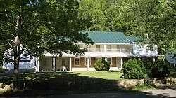
Mechanicsburg, also known as Mechanicsville, is an unincorporated community in Hampshire County, West Virginia, United States. It is located on the Northwestern Turnpike ( U.S. Route 50) west of Romney at Mill Creek Gap (sometimes referred to as Mechanicsburg Gap). Mechanicsburg is the site of "The Burg" (c. 1769), used as a headquarters by both armies during the American Civil War. Along Fox Hollow Road (County Route 50/4) lies the 19th-century Fox's Hollow Baptist Church and the old Mechanicsburg School.
The Fox's Hollow area of Mechanicsburg is currently experiencing major residential development, including Silver Leaf, a community of wooded five and 10-acre (40,000 m2) lots.
References
External links
![]() Media related to
Mechanicsburg, West Virginia at Wikimedia Commons
Media related to
Mechanicsburg, West Virginia at Wikimedia Commons


