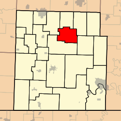
McDowell Township | |
|---|---|
 | |
| Coordinates: 36°49′31″N 093°47′52″W / 36.82528°N 93.79778°W | |
| Country | United States |
| State | Missouri |
| County | Barry |
| Area | |
| • Total | 23.85 sq mi (61.78 km2) |
| • Land | 23.85 sq mi (61.78 km2) |
| • Water | 0 sq mi (0 km2) 0% |
| Elevation | 1,296 ft (395 m) |
| Population (
2000) | |
| • Total | 275 |
| • Density | 11.5/sq mi (4.5/km2) |
| FIPS code | 29-44966 [2] |
| GNIS feature ID | 0766260 |
McDowell Township is one of twenty-five townships in Barry County, Missouri, United States. In the 1890s, the McDowell mines mined extracted lead and jack ore. [3] [4] As of the 2000 census, its population was 275.
Geography
McDowell Township covers an area of 23.85 square miles (61.8 km2) and contains no incorporated settlements.
The streams of Brights Spring, Calton Creek, Gunter Creek, Little Flat Creek, Stansberry Creek and Willow Branch run through this township.
References
- ^ "US Board on Geographic Names". United States Geological Survey. October 25, 2007. Retrieved January 31, 2008.
- ^ "U.S. Census website". United States Census Bureau. Retrieved January 31, 2008.
-
^ McGuffin, J.B., ed. (August 15, 1893). "As Others See Us". The Granada Gazette.
A high grade of lead and jack ore is being mined at McDowell, Barry county, Mo., and it is believed that the county around there is likely to become a mining camp of no mean proportions.
- ^ "McDowell". Barry County Museum. Cassville, MO. Retrieved July 12, 2022.
External links
