McCauleyville | |
|---|---|
 McCauleyville  McCauleyville | |
| Coordinates: 46°26′30″N 96°42′28″W / 46.44167°N 96.70778°W | |
| Country | United States |
| State | Minnesota |
| County | Wilkin |
| Elevation | 935 ft (285 m) |
| Time zone | UTC-6 ( Central (CST)) |
| • Summer ( DST) | UTC-5 (CDT) |
| Area code | 218 |
| GNIS feature ID | 647659 [1] |
McCauleyville is an unincorporated community in Wilkin County, in the U.S. state of Minnesota. [1]
History
A post office called McCauleysville was established in 1873, and remained in operation until 1905. [2] The community was named for its founder, David McCauley. [3] David McCauley served as post sutler as well as postmaster and stagecoach agent at nearby Fort Abercrombie in the early 1860s and was present during the siege by the Dakota in 1862.
References
- ^ a b U.S. Geological Survey Geographic Names Information System: McCauleyville, Minnesota
- ^ "Wilkin County". Jim Forte Postal History. Retrieved August 14, 2015.
- ^ Upham, Warren (1920). Minnesota Geographic Names: Their Origin and Historic Significance. Minnesota Historical Society. p. 578.
Municipalities and communities of
Wilkin County, Minnesota, United States | ||
|---|---|---|
| Cities | 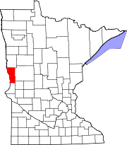 | |
| Townships | ||
|
Unincorporated communities | ||
| Footnotes | ‡This populated place also has portions in an adjacent county or counties | |