56°00′32″N 37°12′19″E / 56.00889°N 37.20528°E
Matushkino District
Ма́тушкино | |
|---|---|
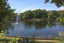
 Bykovo Pond in Zelenograd, Matushkino District | |
|
Location of Matushkino District on the map of Moscow | |
| Coordinates: 56°0′32″N 37°12′19″E / 56.00889°N 37.20528°E | |
| Country | Russia |
| Federal subject | Moscow |
| Population | |
| • Estimate (2018)
[1] | 40,351 |
| Time zone |
UTC+3 (
MSK
|
| OKTMO ID | 45331000 |
| Website | http://matushkino.mos.ru/ |
Matushkino ( Russian: Ма́тушкино) is a district of Moscow within Zelenogradsky Administrative Okrug.
See also
References
Notes
- ^ "26. Численность постоянного населения Российской Федерации по муниципальным образованиям на 1 января 2018 года". Federal State Statistics Service. Retrieved 23 January 2019.
- ^ "Об исчислении времени". Официальный интернет-портал правовой информации (in Russian). 3 June 2011. Retrieved 19 January 2019.

