Matei
Szentmáté | |
|---|---|
 View of Corvinești village | |
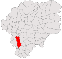
 Location in Bistrița-Năsăud County | |
| Coordinates: 46°59′N 24°16′E / 46.983°N 24.267°E | |
| Country | Romania |
| County | Bistrița-Năsăud |
| Government | |
| • Mayor (2020–2024) | Vasile Encian ( PNL) |
| Area | 86.02 km2 (33.21 sq mi) |
| Elevation | 330 m (1,080 ft) |
| Population (2021-12-01)
[1] | 2,332 |
| • Density | 27/km2 (70/sq mi) |
| Time zone | EET/ EEST (UTC+2/+3) |
| Postal code | 427135 |
| Area code | +40 x59 |
| Vehicle reg. | BN |
| Website |
comunamatei |
Matei ( Hungarian: Szentmáté; German: Mathesdorf) is a commune in Bistrița-Năsăud County, Transylvania, Romania. It is composed of six villages: Bidiu (Bödön), Corvinești (Kékesújfalu), Enciu (Szászencs), Fântânele (Újős), Matei, and Moruț (Aranyosmóric).
Geography
The commune lies on the Transylvanian Plateau, in the Nösnerland historic region of northeastern Transylvania. It is located in the southern part of Bistrița-Năsăud County, at a distance of 27 km (17 mi) from the town of Beclean and 34 km (21 mi) from the county seat, Bistrița; the city of Gherla is 38 km (24 mi) to the west, in Cluj County.
Demographics
At the 2011 census, 52.3% of inhabitants were Romanians, 40.6% Hungarians, 5.8% Roma, and 1.2% Germans. At the 2021 census, Matei commune had a population of 2,332, of which 51.84% were Romanians, 36.49% Hungarians, and 3.56% Roma. [2]
Natives
- Ioan Nagy (born 1954), footballer
References


