| Manzanita Lake | |
|---|---|
| Lago Manzanita ( Spanish) | |

Lassen Peak
reflected in Manzanita Lake | |
 Manzanita Lake  Manzanita Lake | |
| Location | Lassen Volcanic National Park, Shasta County, California, US |
| Coordinates | 40°32′01″N 121°34′04″W / 40.53371°N 121.56780°W |
| Basin countries | United States |
Manzanita Lake is a lake located in Lassen Volcanic National Park. The name means "little apple" in Spanish.
Manzanita Lake was formed when Manzanita Creek was dammed 300 years ago by a rock avalanche from the northwest slope of the Chaos Crags, which also resulted in the debris formation known as Chaos Jumbles. [1]
The area around the lake features the Loomis Museum, a campground, and the Manzanita Lake Naturalist's Services Historic District. Located near the park entrance, the lake is open for fishing and has rainbow, brown and brook trout. [2]
Climate
Manzanita Lake has a warm-summer humid continental climate ( Dsb) using the 0 °C isotherm or a warm-summer mediterranean climate ( Csb) using the -3 °C isotherm with short, warm summers and cool winters, with most precipitation falling in the winter months.
| Climate data for Manzanita Lake, California, 1991–2020 normals, extremes 1949–present | |||||||||||||
|---|---|---|---|---|---|---|---|---|---|---|---|---|---|
| Month | Jan | Feb | Mar | Apr | May | Jun | Jul | Aug | Sep | Oct | Nov | Dec | Year |
| Record high °F (°C) | 67 (19) |
68 (20) |
71 (22) |
78 (26) |
88 (31) |
94 (34) |
97 (36) |
96 (36) |
96 (36) |
88 (31) |
78 (26) |
68 (20) |
97 (36) |
| Mean maximum °F (°C) | 55.2 (12.9) |
56.2 (13.4) |
61.5 (16.4) |
69.0 (20.6) |
77.8 (25.4) |
85.6 (29.8) |
89.8 (32.1) |
89.0 (31.7) |
85.7 (29.8) |
76.6 (24.8) |
63.5 (17.5) |
54.4 (12.4) |
91.5 (33.1) |
| Mean daily maximum °F (°C) | 41.1 (5.1) |
41.8 (5.4) |
46.0 (7.8) |
50.2 (10.1) |
60.7 (15.9) |
69.5 (20.8) |
78.8 (26.0) |
78.3 (25.7) |
72.4 (22.4) |
58.7 (14.8) |
47.1 (8.4) |
39.5 (4.2) |
57.0 (13.9) |
| Daily mean °F (°C) | 31.5 (−0.3) |
31.8 (−0.1) |
35.1 (1.7) |
38.8 (3.8) |
47.9 (8.8) |
55.3 (12.9) |
62.6 (17.0) |
61.6 (16.4) |
56.5 (13.6) |
46.0 (7.8) |
36.6 (2.6) |
30.6 (−0.8) |
44.5 (7.0) |
| Mean daily minimum °F (°C) | 21.8 (−5.7) |
21.7 (−5.7) |
24.3 (−4.3) |
27.5 (−2.5) |
35.1 (1.7) |
41.0 (5.0) |
46.4 (8.0) |
44.9 (7.2) |
40.6 (4.8) |
33.4 (0.8) |
26.2 (−3.2) |
21.7 (−5.7) |
32.1 (0.0) |
| Mean minimum °F (°C) | 6.8 (−14.0) |
9.1 (−12.7) |
9.4 (−12.6) |
15.3 (−9.3) |
24.8 (−4.0) |
29.5 (−1.4) |
36.8 (2.7) |
36.4 (2.4) |
30.1 (−1.1) |
23.8 (−4.6) |
13.3 (−10.4) |
7.1 (−13.8) |
2.4 (−16.4) |
| Record low °F (°C) | −13 (−25) |
−11 (−24) |
−7 (−22) |
−2 (−19) |
11 (−12) |
19 (−7) |
26 (−3) |
28 (−2) |
19 (−7) |
10 (−12) |
2 (−17) |
−13 (−25) |
−13 (−25) |
| Average precipitation inches (mm) | 6.50 (165) |
5.51 (140) |
6.43 (163) |
4.30 (109) |
2.90 (74) |
1.32 (34) |
0.34 (8.6) |
0.29 (7.4) |
0.65 (17) |
2.70 (69) |
4.68 (119) |
6.49 (165) |
42.11 (1,071) |
| Average snowfall inches (cm) | 33.1 (84) |
34.9 (89) |
33.9 (86) |
20.8 (53) |
6.3 (16) |
0.8 (2.0) |
trace | 0.0 (0.0) |
0.1 (0.25) |
3.9 (9.9) |
11.8 (30) |
31.7 (81) |
177.3 (451.15) |
| Average extreme snow depth inches (cm) | 31.3 (80) |
37.4 (95) |
38.8 (99) |
21.3 (54) |
4.6 (12) |
0.7 (1.8) |
0.0 (0.0) |
0.0 (0.0) |
0.1 (0.25) |
2.6 (6.6) |
8.6 (22) |
21.8 (55) |
46.3 (118) |
| Average precipitation days (≥ 0.01 in) | 12.9 | 11.5 | 12.1 | 10.2 | 7.8 | 4.4 | 1.3 | 1.5 | 3.0 | 5.9 | 11.0 | 12.7 | 94.3 |
| Average snowy days (≥ 0.1 in) | 9.4 | 9.2 | 8.6 | 6.1 | 1.9 | 0.4 | 0.0 | 0.0 | 0.1 | 1.1 | 5.4 | 8.9 | 51.1 |
| Source 1: NOAA (snow, snow days, precip days 1981–2010) [3] [4] | |||||||||||||
| Source 2: National Weather Service [5] | |||||||||||||
Gallery
-
 View of Chaos Crags and Lassen Peak from the lakeshore.
 -
 Fishing on Manzanita Lake.
 -
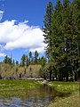 The shore of Manzanita Lake.


See also
References
- ^ Hill, Richard L. (2004-10-01). Volcanoes of the Cascades: Their Rise and Their Risks. Falcon. pp. 86–87. ISBN 978-0-7627-3072-8.
- ^ "Manzanita Lake". Wild Trout & Catch-and-Release Waters. California Department of Fish and Game. 2003. Retrieved May 12, 2006.
- ^ "U.S. Climate Normals Quick Access – Station: Manzanita Lake, CA (1991–2020)". National Oceanic and Atmospheric Administration. Retrieved December 31, 2022.
- ^ "U.S. Climate Normals Quick Access – Station: Manzanita Lake, CA (1981–2010)". National Oceanic and Atmospheric Administration. Retrieved December 31, 2022.
- ^ "NOAA Online Weather Data – NWS Sacramento". National Weather Service. Retrieved December 31, 2022.
External links
-
 Media related to
Manzanita Lake at Wikimedia Commons
Media related to
Manzanita Lake at Wikimedia Commons