Manhasset Viaduct | |
|---|---|
 The Manhasset Viaduct, as seen from the Thomaston side, looking northeast. | |
| Coordinates | 40°47′33″N 73°42′36″W / 40.79252°N 73.71008°W |
| Carries | The Port Washington Branch of the Long Island Rail Road |
| Crosses | Manhasset Bay |
| Locale | Village of Thomaston and Hamlet of Manhasset |
| Owner | Metropolitan Transportation Authority |
| Maintained by | Metropolitan Transportation Authority |
| Characteristics | |
| Design | Steel stringer bridge |
| Material | Steel |
| Total length | 679 feet (207 meters) |
| Height | 81 feet (25 meters) |
| Rail characteristics | |
| No. of tracks | 1 |
| Track gauge | 4 feet, 8+1⁄2 inches (220 millimeters) ( Standard gauge) |
| Electrified | October 21, 1913 |
| History | |
| Constructed by |
King Bridge Co. Carnegie Steel Company |
| Opened | June 23, 1898 |
| Location | |
|
| |
The Manhasset Viaduct (also known as the Manhasset Valley Bridge) is a railroad bridge located between the Village of Thomaston and the Hamlet of Manhasset, on Long Island, in the State of New York. It carries the Port Washington Branch of the Long Island Rail Road. [1]
Description
The bridge was completed in 1898, and opened on June 23 of that year, as part of the Port Washington Branch's extension from Great Neck to Port Washington. [2] [3] [4] At an average height of 81 feet (25 meters) above the water and measuring 679 feet (207 meters) in length, the bridge is the highest on the entire LIRR network. [2] [1] In 1913, the remainder of the Port Washington Branch east of the former split with the former Whitestone Branch was electrified, and thus including the portion over this bridge. [5]
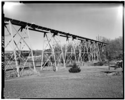
The bridge, which is of a steel stringer design, was built by the Cincinnati, Ohio-based King Bridge Company, as well as the Carnegie Steel Company. [3] [6] [7]
The Manhasset Viaduct is a significant and vital component of the Port Washington Branch's infrastructure, as it is what enables the line to traverse the Manhasset Valley; the extension to Port Washington required the construction of this crossing. [3]

In addition to crossing Manhasset Bay, the bridge also goes over East Shore Road (on its west end) and Bayview Avenue (on its east end).
[6]
See also
References
- ^ a b Keller, David; Lynch, Steven (2005). Revisiting the Long Island Rail Road: 1925-1975. Images of Rail. Arcadia Publishing. ISBN 9780738538297.
- ^ a b Seyfried, Vincent F. (1975). "Part Six The Golden Age 1881-1900". The Long Island Rail Road: A Comprehensive History. Long Island: Vincent F. Seyfried. Archived from the original on April 19, 2015.
- ^ a b c "LIRR". Cow Neck Peninsula Historical Society. Retrieved 2020-08-14.
- ^ "Port Washington's Great Gala Day". The Brooklyn Times. June 23, 1898. Retrieved 2023-07-22 – via Newspapers.com.
- ^ "LIRR Branch Notes". www.trainsarefun.com. Retrieved 2020-08-13.
- ^ a b "LIRR - Manhasset Viaduct". Bridgehunter.com. Retrieved 2020-08-13.
- ^ Sloan, Allan King (October 2005). "The Manhasset Viaduct". King Bridge Company. Archived from the original on March 3, 2006.