You can help expand this article with text translated from
the corresponding article in German. (March 2009) Click [show] for important translation instructions.
|
Mainburg | |
|---|---|
 City center of Mainburg | |
 Coat of arms | |
Location of Mainburg within Kelheim district 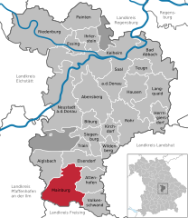 | |
 Mainburg  Mainburg | |
| Coordinates: 48°39′N 11°47′E / 48.650°N 11.783°E | |
| Country | Germany |
| State | Bavaria |
| Admin. region | Niederbayern |
| District | Kelheim |
| Government | |
| • Mayor (2020–26) | Helmut Fichtner [1] ( FW) |
| Area | |
| • Total | 61.59 km2 (23.78 sq mi) |
| Elevation | 422 m (1,385 ft) |
| Population (2022-12-31)
[2] | |
| • Total | 15,466 |
| • Density | 250/km2 (650/sq mi) |
| Time zone | UTC+01:00 ( CET) |
| • Summer ( DST) | UTC+02:00 ( CEST) |
| Postal codes | 84042–84048 |
| Dialling codes | 08751 |
| Vehicle registration | KEH, MAI, PAR, RID, ROL |
| Website | www.mainburg.de |
Mainburg is a town in the district of Kelheim, in Bavaria, Germany. It is situated on the river Abens, 30 km northwest of Landshut and 30 km southeast of Ingolstadt.
Mainburg borders four communities; Aiglsbach, Elsendorf, Attenhofen, and Volkenschwand. The town has 15,163 residents, the third largest in its district. [3]

References
- ^ Liste der ersten Bürgermeister/Oberbürgermeister in kreisangehörigen Gemeinden, Bayerisches Landesamt für Statistik, 15 July 2021.
- ^ Genesis Online-Datenbank des Bayerischen Landesamtes für Statistik Tabelle 12411-003r Fortschreibung des Bevölkerungsstandes: Gemeinden, Stichtag (Einwohnerzahlen auf Grundlage des Zensus 2011) ( Hilfe dazu).
- ^ "Spreadsheet "Data 2", Statistical Report A1200C 202041 Population of the municipalities, districts and administrative districts 1st quarter, 2020". Retrieved 2021-01-27.
Towns and municipalities in
Kelheim (district) | ||
|---|---|---|
 | ||
|
| This Kelheim district location article is a stub. You can help Wikipedia by expanding it. |
| International | |
|---|---|
| National | |
| Geographic | |