 The
William Jasper Monument in the square | |
| Namesake | James Madison |
|---|---|
| Maintained by | City of Savannah |
| Location | Savannah, Georgia, U.S. |
| Coordinates | 32°04′25″N 81°05′38″W / 32.0735°N 81.0939°W |
| North | Bull Street |
| East | East Macon Street |
| South | Bull Street |
| West | West Macon Street |
| Construction | |
| Completion | 1837 |
Madison Square is one of the 22 squares of Savannah, Georgia, United States. It is located in the fourth row of the city's five rows of squares, on Bull Street and Macon Street, and was laid out in 1837. It is south of Chippewa Square, west of Lafayette Square, north of Monterey Square and east of Pulaski Square. The square is named for James Madison, fourth president of the United States. The oldest building on the square is the Sorrel–Weed House, at 6 West Harris Street, which dates to 1840. [1]
In the center of the square is the William Jasper Monument, an 1888 work by Alexander Doyle memorializing Sergeant William Jasper, a soldier in the siege of Savannah who, though mortally wounded, recovered his company's banner. [2] Savannahians sometimes refer to this as Jasper Square, in honor of Jasper's statue. [3]
Madison Square features a vintage cannon from the Savannah Armory. [4] These now mark the starting points of the first highways in Georgia, the Ogeechee Road, leading to Darien, and the Augusta Road. [2] [5]
The square also includes a monument marking the center of the British resistance during the siege. [6]
The Masonic Hall, at 341 Bull Street, was designed by Hyman Witcover, also the architect of Savannah City Hall. [7]
In 1971 Savannah landscape architect Clermont Huger Lee and Mills B. Lane planned and initiated a project to install new walk patterns with offset sitting areas and connecting walks at curbs, add new benches, lighting and planting. [8]
Dedication
| Namesake | Image | Note |
|---|---|---|
| James Madison |

|
The square is named for James Madison (1751–1836), fourth president of the United States. |
Markers and structures
| Name | Image | Note |
|---|---|---|
| William Jasper Monument |

|
Madison Square and the William Jasper Monument. |
| Historical marker |

|
The square's historical marker, erected by the Georgia Historical Commission in 1958. |
| Historical marker |

|
Ancient and Accepted Scottish Rite of Freemasonry historical marker, erected in 1969. |
| Historical marker |

|
Cannon. |
Constituent buildings
Each building below is in one of the eight blocks around the square composed of four residential "tything" blocks and four civic ("trust") blocks, now known as the Oglethorpe Plan. They are listed with construction years where known.
- Northwestern residential/tything lot
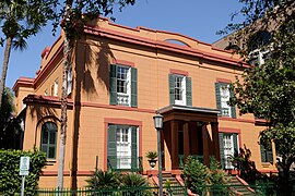
- Sorrel–Weed House, 6 West Harris Street (1840) [1] – oldest building on the square
- Francis Sorrel Property, 12 West Harris Street (1856) [1]
- Eugenia & Louisa Kerr Duplex, 14–18 West Harris Street (1842–1843) – attributed to Charles B. Cluskey
- Eliza Ann Jewett Property (3), 20–22 West Harris Street (1842–1843)
- 24 West Harris Street (1840) [1]
- John Gallie Property, 26 West Harris Street (1840) – now Harris Hall, property of SCAD [9]
- Northwestern civic/trust lot
- Green–Meldrim House, 14 West Macon Street (1850–1853) [1]
- Southwestern civic/trust lot
- St. John's Episcopal Church, 325 Bull Street (1853) [1]
- Southwestern residential/tything lot
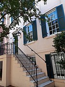
- Masonic Hall, 341 Bull Street (1912/1923) [1] [10] [11] – now Gryphon, part of SCAD
- Daniel Purse Row House, 5–9 West Charlton Street (1879)
- Daniel Robertson Property (1), 11–17 West Charlton Street (1852–1853)
- Daniel Robertson Property (2), 19 West Charlton Street (1857)
- Daniel Robertson Property (3), 23–25 West Charlton Street (1845)
- Northeastern residential/tything lot
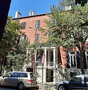
- The DeSoto, 15 East Liberty Street (1968) [1] – replaced the original, 1890-built Hotel DeSoto, designed by William G. Preston
- Northeastern civic/trust lot
- Eliza Ann Jewett Property (1), 326 Bull Street (1843) [1]
- Eliza Ann Jewett Row House, 18–24 East Macon Street (1852–1853) [1]
- Southeastern residential/tything lot
- Poetter Hall, 342 Bull Street (1893) [1]
- Louisa Porter Home, 23 East Charlton Street, Savannah, Georgia (1853) [12]
Gallery
-
 The DeSoto Hotel, 15 East Liberty Street
 -
 Green–Meldrim House, 14 West Macon Street
 -
 Poetter Hall, 342 Bull Street
 -
 Sorrel–Weed House, 6 West Harris Street
 -
 St. John's Episcopal Church, 325 Bull Street
 -
 Eliza Ann Jewett House, 326 Bull Street
 -
 Eliza Ann Jewett Row House, 18–24 East Macon Street
 -
 Masonic Temple, 341 Bull Street
 -
 Daniel Purse Row House, 5–9 West Charlton Street
 -
 Daniel Robertson Property (1), 11–17 West Charlton Street
 -
 Daniel Robertson Property (2), 19 West Charlton Street
 -
 Daniel Robertson Property (3), 23–25 West Charlton Street
 -
 Francis Sorrel Property, 12 West Harris Street
 -
 Eugenia & Louisa Kerr Duplex, 14–18 West Harris Street
 -
 Eliza Ann Jewett Property (3), 20–22 West Harris Street
 -
 John Gallie Property, 26 West Harris Street


.jpg)


References
- ^ a b c d e f g h i j k Historic Building Map: Savannah Historic District – Historic Preservation Department of the Chatham County-Savannah Metropolitan Planning Commission (November 17, 2011), p. 49
- ^ a b City of Savannah's monuments page This page links directly to numerous short entries, many accompanied by photographs, discussing a variety of monuments, memorials, etc., in the squares and elsewhere. Accessed June 16, 2007.
- ^ Chan Sieg (1984). The squares: an introduction to Savannah. Virginia Beach: Donning.
- ^ Savannah Scene magazine, May–June 2007, pp 10–11, accessed June 16, 2007.
- ^ Our Coast's guide to Savannah's Squares, accessed June 16, 2007. Site features an excellent interactive map of Savannah's squares and numerous photographs.
- ^ See Savannah by T.D. Conner (2001), accessed June 14, 2007
- ^ Savannah, Whip Morrison Triplett, 2006, p. 82 ISBN 9780738542096
- ^ Dolder, Ced (Spring 2014). "Clermont Lee, (1914-2006) Pioneering Savannah Landscape Architect" (PDF). Magnolia – Publication of the Southern Garden History Society. XXVII (2): 4. Retrieved 16 February 2020.
- ^ SCAD Fact Book: 2020–21
- ^ "Freemasons sell historic Bull Street home to SCAD" – Savannah Morning News, February 18, 2020
- ^ Gryphon – SCAD.edu
- ^ Lost Savannah: Photographs from the Collection of the Georgia Historical Society, Luciana M. Spracher (2003) ISBN 9780738514871