Luvinate | |
|---|---|
| Comune di Luvinate | |
 Luvinate Location of Luvinate in Italy  Luvinate Luvinate (Lombardy) | |
| Coordinates: 45°50′N 8°46′E / 45.833°N 8.767°E | |
| Country | Italy |
| Region | Lombardy |
| Province | Province of Varese (VA) |
| Area | |
| • Total | 4.2 km2 (1.6 sq mi) |
| Population (Dec. 2004)
[2] | |
| • Total | 1,389 |
| • Density | 330/km2 (860/sq mi) |
| Demonym | Luvinatesi |
| Time zone | UTC+1 ( CET) |
| • Summer ( DST) | UTC+2 ( CEST) |
| Postal code | 21020 |
| Dialing code | 0332 |
| Website | Official website |
Luvinate is a comune (municipality) in the Province of Varese in the Italian region Lombardy, located about 50 kilometres (31 mi) northwest of Milan and about 5 kilometres (3 mi) northwest of Varese. As of 31 December 2004, it had a population of 1,389 and an area of 4.2 square kilometres (1.6 sq mi). [3]
Luvinate borders the following municipalities: Barasso, Casciago, Castello Cabiaglio, Varese.
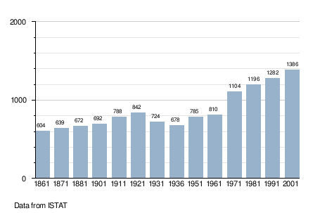
Demographic evolution
References
- ^ "Superficie di Comuni Province e Regioni italiane al 9 ottobre 2011". Italian National Institute of Statistics. Retrieved 16 March 2019.
- ^ "Popolazione Residente al 1° Gennaio 2018". Italian National Institute of Statistics. Retrieved 16 March 2019.
- ^ All demographics and other statistics: Italian statistical institute Istat.
External links
|
| This article on a location in the Province of Varese is a stub. You can help Wikipedia by expanding it. |