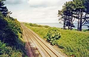
Lunan Bay | |
|---|---|
 The site of the station, looking northeast towards Montrose, in 2002 | |
| General information | |
| Location |
Lunan,
Angus Scotland |
| Coordinates | 56°39′43″N 2°30′21″W / 56.662°N 2.5058°W |
| Grid reference | NO690523 |
| Platforms | 2 |
| Other information | |
| Status | Disused |
| History | |
| Original company | North British, Arbroath and Montrose Railway |
| Pre-grouping |
North British, Arbroath and Montrose Railway North British Railway |
| Post-grouping | LNER |
| Key dates | |
| 1 May 1883 | Opened |
| 22 September 1930 | Closed to passengers |
| 18 May 1964 | Closed to goods |
Lunan Bay railway station served the village of Lunan, Angus, Scotland from 1883 to 1964 on the North British, Arbroath and Montrose Railway.
History
The station opened on 1 May 1883 by the North British, Arbroath and Montrose Railway. [1] The goods yard was to the west. The station closed to passengers on 22 September 1930 [2] and closed to goods traffic on 18 May 1964. [3]
References
- ^ Quick, M E (2002). Railway passenger stations in England, Scotland and Wales - a chronology. Richmond: Railway and Canal Historical Society. p. 267. OCLC 931112387.
- ^ "Lunan Bay Station". Canmore. Retrieved 27 July 2018.
- ^ "Site of Lunan Bay station, 2002 © Ben Brooksbank :: Geograph Britain and Ireland". Geograph. Retrieved 1 March 2021.
External links
| Preceding station | Historical railways | Following station | ||
|---|---|---|---|---|
|
Montrose Line and station open |
North British, Arbroath and Montrose Railway |
Inverkeilor Line open, station closed | ||