| Lost Creek State Park | |
|---|---|
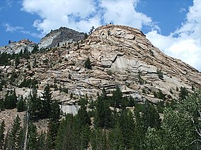
 Limestone cliffs, Summer 2008 | |
| Location |
Deer Lodge County,
Montana United States |
| Nearest town | Anaconda, Montana |
| Coordinates | 46°12′39″N 113°00′17″W / 46.21083°N 113.00472°W [1] |
| Area | 502 acres (203 ha) [2] |
| Elevation | 6,424 ft (1,958 m) [1] |
| Designation | Montana state park |
| Established | 1957 [3] |
| Administrator | Montana Fish, Wildlife & Parks |
| Website |
stateparks |
Lost Creek State Park is a 502-acre (203 ha) public recreation area in Deer Lodge County, Montana, United States, [1] about 6 miles (9.7 km) north of Anaconda.
Description
The state park was created in 1957 [3] and features limestone cliffs and multi-colored rock formations that rise 1,200 feet (370 m) above a narrow canyon floor. A short walking trail leads to Lost Creek Falls, which plunge 50 feet (15 m). The park offers seasonal camping, fishing, picnicking, bicycling, hiking and wildlife viewing with mountain goats and bighorn sheep commonly seen. [2]
See also
References
- ^ a b c "Lost Creek State Park". Geographic Names Information System. United States Geological Survey, United States Department of the Interior.
- ^ a b "Lost Creek State Park". Montana Fish, Wildlife and Parks. Retrieved September 19, 2012.
- ^ a b "Park Origin by Date". Montana State Parks. 2014. Retrieved June 13, 2018.
External links
Wikimedia Commons has media related to
Lost Creek State Park (Montana).
- Official website
- Lost Creek State Park Trail Map Montana Fish, Wildlife & Parks

