There are two operating offshore wind farms in the United States, and several more are in permitting or under construction. The Bureau of Ocean Energy Management studies potential sites in federal waters for offshore wind energy development and leases sites to developers, who work with state regulatory agencies to interconnect and market their electricity.
Operational utility scale
| Wind farm | Offshore BOEM wind energy lease area | Receiving
states |
Coordinates |
Capacity ( MW) |
Completion year | Turbines | Developer /Utility |
Regulatory agency | Refs | ||
|---|---|---|---|---|---|---|---|---|---|---|---|
| Block Island Wind | Rhode Island state waters | RI | 41°06′52.96″N 71°31′16.18″W / 41.1147111°N 71.5211611°W | 30 | 2016 | 5 x 6MW Haliade 150 | Ørsted | Rhode Island PUC | [1] [2] | ||
| Coastal Virginia Offshore Wind - Pilot Project | Offshore
Virginia OCS-A 0497 [3] |
25 nmi (nautical miles) east of Cape Henry (VA) | 2,135 acres (864 ha) | VA | 36°53′30″N 75°29′30″W / 36.89167°N 75.49167°W | 12 | 2020 | 2 x 6MW Siemens Gamesa SWT-6.0-154 |
Ørsted Dominion Energy |
State Corporation Commission | [4] [5] |
| South Fork |
Massachusetts &
Rhode Island OCS-A 0517 (North Lease Area) [6] |
26 nmi southeast of Montauk Point, Long Island (NY) & 16.6 nmi southeast of Block Island (RI) | 13,700 acres (5,500 ha) | NY | 41°05′31″N 71°18′40″W / 41.092°N 71.311161°W | 132 | 2024 | 12 x 11MW Siemens Gamesa 11.0-200 DD |
Ørsted Global Infrastructure Partners |
NYSERDA | [7] [8] [9] [10] [11] |
Under construction
The following table lists offshore wind farms that have begun construction in federal waters. Some of these projects have begun delivering power to the grid, with few of their turbines coming online.
| Wind farm | Offshore
BOEM wind
energy lease area |
Receiving states | Coordinates |
Capacity ( MW) |
Projected completion | Turbines | Developer | Regulatory agency /Utility |
Refs | ||
|---|---|---|---|---|---|---|---|---|---|---|---|
| Vineyard Wind | Offshore
Massachusetts OCS-A 0501 [12] [13] |
13 nmi southwest of Martha's Vineyard (MA) | 65,296 acres (26,424 ha) | MA | 41°02′00″N 70°37′00″W / 41.03325°N 70.61667°W | 806 | 2024 | 62 13MW GE Haliade-X |
Avangrid Copenhagen Infrastructure Partners |
Massachusetts Department of Public Utilities | [14] [15] [16] [17] [18] |
Proposed wind farms
Atlantic Coast
The following table lists offshore wind farm areas (by nameplate capacity) that are in various states development for the Outer Continental Shelf in U.S. territorial waters of the East Coast of the United States, [19] where a Bureau of Ocean Energy Management (BOEM) wind energy area lease has been secured [20] [21] and have gained at least some required regulatory approval before construction can begin. Distances are approximated and generally represent closest point of turbine array to shoreline, while acreage represents size of total lease area, which may be shared, and not the blocks within them allocated for the wind farm.
Projects that have received operations approval from BOEM are highlighted in blue.
| Wind farm | Offshore
BOEM wind
energy lease area |
Receiving states | Coordinates |
Capacity ( MW) |
Projected completion | Turbines | Developer | Regulatory agency /Utility |
Refs | ||
|---|---|---|---|---|---|---|---|---|---|---|---|
| Atlantic Shores | Offshore
New Jersey OCS-A 0499 (NJWEA North) [22] |
13 nmi east of Atlantic City (NJ) [23] | 183,353 acres (74,200 ha) | NJ | 1,510 | 2028 | Vestas V236-15MW | Shell New Energies | NJBPU | [24] [25] [26] | |
| Attentive Energy Two | Offshore New York/New Jersey OCS-A 0538 |
47 nmi southeast of Jones Beach (NY) & 36 nmi east of Seaside Heights(NJ) | 84,332 acres (34,128 ha) | NJ | 1,342 | 2031 | TotalEnergies,
Rise Light & Power, Corio Generation |
NJBPU | [27] | ||
| Coastal Virginia Offshore Wind | Offshore
Virginia OCS-A 0483 [28] |
25 to 35 nmi east of Cape Henry (VA) | 112,799 acres (45,648 ha) | VA | 36°54′N 75°23′W / 36.9°N 75.38°W | 2,640 | 2026 | 176 Siemens Gamesa 14-222 DD | Dominion Energy | State Corporation Commission | [4] [29] [30] [31] [32] [33] [34] |
| Empire Wind 1 | Offshore
New York OCS-A 0512 ( Hudson North) [35] [36] |
12 nmi south of Jones Beach, Long Island (NY) | 79,350 acres (32,110 ha) | NY | 40°19′45″N 73°30′28″W / 40.329226°N 73.507861°W | 816 | 2027 |
Vestas
V236-15MW |
Equinor |
NYSERDA | [37] [38] [39] [40] |
| Kitty Hawk North Wind | Offshore
North Carolina OCS-A 0508 [41] |
24 nmi east of Corolla (NC) | 122,405 acres (49,536 ha) | NC | 800 | 2027 | Up to 69 WTGs | Avangrid Renewables | [42] [43] [44] | ||
| Leading Light Wind | Offshore
New Jersey OCS-A 0542 |
30 nmi east of NJ | NJ | 2,400 | 2031 |
Invenergy
energyRE |
NJBPU | [27] | |||
| MarWin | Offshore
Maryland OCS-A 0490 [45] |
26 nmi east of Ocean City (MD) | 46,970 acres (19,010 ha) | MD | 300 | 2025 | 22 | US Wind | Maryland PSC | [1] [2] [46] [47] [48] [49] [50] [51] | |
| Momentum Wind | 808 | 2027 | |||||||||
| Revolution Wind | Offshore
Rhode Island OCS-A 0486 (North Lease Area) [52] |
halfway between Montauk Point (NY) & Martha's Vineyard (MA) | 83,798 acres (33,912 ha) [53] |
RI CT |
41°07′30″N 71°23′17″W / 41.124974°N 71.38818°W | 704 | 2025 | 64 Siemens Gamesa 11.0-200 DD |
Ørsted Global Infrastructure Partners National Grid United Illuminating |
Connecticut DEEP Rhode Island PUC |
[54] [55] [56] |
| Sunrise Wind | Offshore
Massachusetts &
Rhode Island OCS-A 0487 (North Lease Area) [57] |
26 nmi east of Montauk Point, Long Island (NY) & 16.6 nmi southeast of Block Island (RI) | 86,823 acres (35,136 ha) | NY | 40°59′36″N 71°07′16″W / 40.99333°N 71.12122°W | 924 | 2026 | 84 Siemens Gamesa 11.0-200 DD |
Ørsted Con Ed Transmission |
NYSERDA | [37] [58] [59] [60] |
| Carolina Long Bay | Offshore
North Carolina
OCS-A 0545 OCS-A 0546 |
20 nmi southeast of Southport, North Carolina | NC | 2,250 | 2030 | TBA | TotalEnergy Renewables USA | [61] [62] [63] | |||
Pacific and Gulf of Mexico coasts
In October 2021, the Biden administration approved the initiation of mapping out potential lease areas along the Pacific and Gulf of Mexico coasts. [64] In March 2022, five areas off the coast of California were defined for lease. [65] An auction in December 2022 leased the areas for a total of $757 million. [66]
| Wind farm | Offshore BOEM wind energy lease area | Receiving state | Coordinates |
Capacity ( MW) |
Projected completion | Turbines | Developer /Utility |
Regulatory agency | Refs | ||
|---|---|---|---|---|---|---|---|---|---|---|---|
| TBA | Offshore Northern California
OCS-P 0561 |
63,338 acres (25,632 ha) | CA | RWE Offshore Wind Holdings | [66] | ||||||
| TBA | Offshore Northern California
OCS-P 0562 |
69,031 acres (27,936 ha) | CA | California North Floating | [66] | ||||||
| TBA | Offshore Central California
OCS-P 0563 |
80,062 acres (32,400 ha) | CA | Equinor Wind US | [66] | ||||||
| TBA | Offshore Northern California
OCS-P 0564 |
80,418 acres (32,544 ha) | CA | Central California Offshore Wind | [66] | ||||||
| TBA | Offshore Northern California
OCS-P 0565 |
80,418 acres (32,544 ha) | CA | Invenergy California Offshore | [66] | ||||||
Abandoned, postponed or decommissioned
- Cape Wind (Massachusetts) [67]
- Delaware Offshore Wind Farm [68] [69] [70]
- Fisherman's Energy Atlantic City Windfarm [71] [72] (New Jersey). Groundbreaking for the onshore portion of the project took place in December 2014. [73] [74] It was postponed in July 2017. [75]
- Ocean Wind 1 and 2 (New Jersey). Canceled by Ørsted due to poor financial outlook in 2023.
- Icebreaker Wind (Lake Erie, Ohio) [76] 21 MW, placed on hold in 2023. [77]
See also
Notes
- ^ a b "Our offshore wind projects in the U.S." us.orsted.com. Retrieved 2020-11-13.
- ^ a b "Haliade 150-6MW Offshore Wind Turbine". www.ge.com. GE Renewable Energy. Retrieved 2020-11-13.
- ^ "Virginia Activities, Bureau of Ocean Energy Management".
- ^ a b "27 miles off the coast of Virginia, we're leading the clean energy sector in offshore wind". Dominion Energy - Coastal Virginia Offshore Wind. Archived from the original on 2021-02-04.
- ^ Stump, Jessica (December 9, 2020). "CVOW propels emerging US offshore wind market". Offshore.
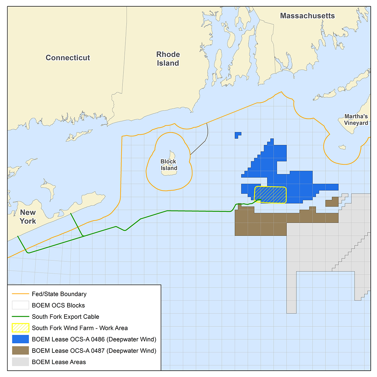
- ^ "BOEM Lease OCS-A 0486 & BOEM Lease OCS-A 0487". BOEM OCS Blocks. Retrieved 2024-01-25.
- ^ "New York awards record 1,700 MW offshore wind contracts". Utility Dive.
- ^ "South Fork - Offshore Wind Farm Project". www.4coffshore.com. 4C Offshore.
- ^ Cardwell, Diane (January 25, 2017). "Nation's Largest Offshore Wind Farm Will Be Built Off Long Island". The New York Times.
- ^ "South Fork Offshore Wind Farm Fact Sheet" (PDF). Long Island Power Authority. Retrieved 2024-01-25.
- ^ "The United States has its first large offshore wind farm, with more to come". AP News. March 14, 2024. Retrieved 2024-03-14.
- ^ "Massachusetts Leases OCS-A 0500 (Bay State Wind) And OCS-A 0501 (Vineyard Wind) ; Bureau of Ocean Energy Management".
- ^ "Commercial Leases OCS-A 0520, 0521, And 0522; Bureau of Ocean Energy Management".
- ^ "Vineyard Wind - Offshore Wind Farm Project". www.4coffshore.com. 4C Offshore.
- ^ "Vineyard Wind". Vineyard Wind.
- ^ "Two big wind farms to rise off coast of Martha's Vineyard". Boston Globe. May 23, 2018. Retrieved 2018-08-11.
- ^ "Vineyard Wind: delayed project reveals bluster in US's offshore wind ambitions". December 4, 2019.
- ^ "Vineyard Wind 1". Vineyard Wind. Retrieved 2023-12-20.
- ^ "The future of US offshore wind: the top ten biggest projects". Recharge. October 28, 2019.
- ^ "BOEM's Renewable Energy Program" (PDF). BOEM. August 2019.
- ^ "State Activities". Bureau of Ocean Energy Management.
- ^ "Commercial Wind Leasing Offshore New Jersey". Bureau of Ocean Energy Management.
- ^ "OCS-A 0499" (PDF). COMMERCIAL LEASE OF SUBMERGED LANDS FOR RENEWABLE ENERGY DEVELOPMENT ON THE OUTER CONTINENTAL SHELF. BOEM. April 2014. Form 0008.
- ^ "Offshore Wind | Project Areas". NJDEP. Retrieved 2022-03-04.
- ^ "Clean Wind Energy in New Jersey & New York". Atlantic Shores Offshore Wind. Retrieved 2022-03-04.
- ^ "Vestas 15 MW Wind Turbines to Spin on Atlantic Shores". OffshoreWIND.biz. Retrieved 2022-10-06.
- ^ a b "Invenergy and TotalEnergies succeed in NJ solicitation". RENEWS.
- ^ "Virginia Activities, Bureau of Ocean Energy Management".
- ^ Geuss, Megan (July 13, 2017). "Virginia utility agrees to install two offshore wind turbines for study". Ars Technica. Retrieved 2017-07-13.
- ^ "Dominion Awarded $47 Million by DOE for Offshore Wind Turbine Demonstration Project". mediaroom.com. Retrieved 2015-05-20.
- ^ "Coastal Virginia Offshore Wind". Dominion Energy.
- ^ "Blue Water wins four projects".
- ^ "'Hats off to the team': steel in water at first US federal water wind farm". Recharge news. Recharge. May 28, 2020. Archived from the original on 2020-06-07.
- ^ "Frequently Asked Questions". coastalvawind.com. Dominion Energy - Coastal Virginia Offshore Wind. Retrieved 2023-12-20.
- ^ "Lease OCS-A 0512". Bureau of Ocean Energy Management.
- ^ "New York Bight". Bureau of Ocean Energy Management.
- ^ a b "New York's Offshore Wind Projects". NYSERDA. Retrieved 2023-05-29.
- ^ "Empire Wind - Offshore Wind Farm Project". www.4coffshore.com. 4C Offshore.
- ^ "Equinor's Empire Wind". www.equinor.com. June 26, 2023.
- ^ "Technology". Empire Wind. December 14, 2023. Retrieved 2023-12-19.
- ^ "North Carolina Activities, Bureau of Ocean Energy Management".
- ^ "Kitty Hawk Offshore".
- ^ "North Carolina Activities". Bureau of Ocean Energy Management.
- ^ "Kitty Hawk North Wind Construction and Operations Plan for Commercial Lease OCS-A 0508". Bureau of Ocean Energy Management.
- ^ "Maryland Activities". Bureau of Ocean Energy Management.
- ^ Rentsch, Julia (November 19, 2019). "Taller, more distant turbines put Ocean City offshore wind projects back under state review". Delmarva Daily Times.
- ^ "Maryland PSC Gives Go-Ahead to US Wind, Deepwater Wind Projects". Offshore Wind. May 11, 2017.
- ^ "US Wind Maryland (MarWin) - Offshore Wind Farm Project". www.4coffshore.com. 4C Offshore.
- ^ "Maryland Offshore Wind Project".
- ^ Cichon, Meg. " Third US Offshore Wind Lease Auction Goes to Italy-based US Wind" 20 August 2014. Accessed: 10 December 2014.
- ^ "Interior Auctions 80,000 Acres Offshore Maryland for Wind Energy Development, Advances President's Climate Action Plan". www.doi.gov. August 19, 2014.
- ^ "Commercial Wind Leasing Offshore Rhode Island And Massachusetts". Bureau of Ocean Energy Management.
- ^ "Commercial Wind Leasing Offshore Rhode Island and Massachusetts". www.boem.gov. Bureau of Ocean Energy Management. Retrieved 2023-12-20.
- ^ "Revolution Wind - Offshore Wind Farm Project". www.4coffshore.com. 4C Offshore.
- ^ "Rhode Island Regulators Approve Revolution Wind Power Contract". us.orsted.com.
- ^ Durakovic, Adnan (October 1, 2021). "Siemens Gamesa Receives Firm Order for Two US Offshore Wind Farms". Offshore Wind. Retrieved 2023-12-20.
- ^ "Sunrise Wind". www.boem.gov. Bureau of Ocean Energy Management. Retrieved 2023-12-21.
- ^ "Sunrise Wind - Offshore Wind Farm Project". www.4coffshore.com. 4C Offshore.
- ^ "Sunrise Wind Final Environmental Impact Statement (FEIS) for Commercial Wind Lease OCS-A 0487". www.boem.gov. Bureau of Ocean Energy Management. Retrieved 2023-12-19.
- ^ "Ørsted's Sunrise Wind project passes key milestone – but turbine number reduced". www.windpowermonthly.com. Retrieved 2023-12-20.
- ^ "Carolina Long Bay". www.boem.gov. Bureau of Ocean Energy Management. Retrieved 2023-10-24.
- ^ "What's next for Wilmington East's $315M windfall?". WilmingtonBiz. Retrieved 2023-07-06.
- ^ McGrath, Gareth. "With an eye out for whales, survey work starts on offshore wind farms south of Wilmington". Wilmington Star-News. Retrieved 2023-10-24.
- ^ Davenport, Coral (October 13, 2021). "Biden Administration Plans Wind Farms Along Nearly the Entire U.S. Coastline". The New York Times.
- ^ "Five California offshore wind leases proposed". National Fisherman.
- ^ a b c d e f "Biden-Harris Administration Announces Winners of California Offshore Wind Energy Auction". doi.gov. December 7, 2022. Retrieved 2022-12-09.
- ^ "After a decade of dithering, the US east coast went all in on offshore wind power this week". Quartz. May 27, 2018. Retrieved 2018-08-11.
- ^ "Agreement Reached On Del. Wind Farm". Washington Post. June 24, 2008. Retrieved 2010-12-13.
- ^ Nathans, Aaron (November 30, 2013). "Two years after Bluewater, offshore wind takes baby steps". Delaware Online. Retrieved 2015-01-24.
- ^ Nathans, Aaron (August 20, 2014). "Maryland takes step closer to offshore wind turbines". Delaware Online. Retrieved 2015-01-24.
- ^ "Fishermen's Energy Atlantic City Windfarm (FACW)". fishermensenergy.com. Archived from the original on 2015-05-18. Retrieved 2015-05-20.
- ^ "Wind power or hot air? Foes question Christie's shift on clean energy". Washington Post. Retrieved 2015-05-20.
- ^ Veselina Petrova (December 24, 2014). "Fishermen's Energy breaks ground on 25-MW offshore wind farm". SeeNews Renewables. Archived from the original on 2015-05-21. Retrieved 2015-05-20.
- ^ "New Jersey wind power project begins construction". elp.com. Retrieved 2015-05-20.
- ^ Lowe, Claire (June 30, 2017). "Without funding, offshore wind project for AC hangs in limbo". Press of Atlantic City. Retrieved 2017-07-13.
- ^ "The Project: Icebreaker Wind". www.leedco.org. LEEDCo. Archived from the original on 2022-08-31. Retrieved 2022-08-31.
- ^ Peter Krouse, cleveland com (December 8, 2023). "Icebreaker Wind project halted, no plans to resurrect effort to put wind turbines in Lake Erie". cleveland. Retrieved 2024-01-29.
External links
- List of U.S. offshore wind projects
- 'Only a matter of time': U.S. offshore wind struggles to get off the ground
- Draft Environmental Impact Statement - produced by the US Army Corps of Engineers
- Opinion piece on wind turbines shifting
- Cape Wind Project Page - company website
- Clean Power Now - a pro-project advocacy group
- Alliance to Protect Nantucket Sound - anti-project advocacy group
- Northeast Ocean Data: Offshore Wind Projects
| Wind power by state |
| |
|---|---|---|
| Large wind farms | ||
| Offshore wind farms |
| |
| Wind power companies | ||