From Wikipedia, the free encyclopedia
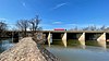
 The Raritan river at its mouth at Raritan Bay, an arm of the Upper New York Bay
This is a list of
road/
highway and
rail crossings of the
Raritan River from the mouth at
Raritan Bay upstream. It also includes crossings of its two branches: the
North Branch Raritan River and the
South Branch Raritan River.
Crossings
| Crossing
|
Image
|
Carries
|
Location
|
Coordinates
|
Main stem
|
|
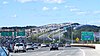
Raritan Bay Drawbridge
|

|
NJ Transit
North Jersey Coast Line
Norfolk Southern Railway
CSX
|
Perth Amboy,
South Amboy
|
40°29′46″N 74°16′52″W / 40.4961°N 74.2810°W / 40.4961; -74.2810 (Raritan Bay Drawbridge)
|
|
Victory Bridge
|

|
 NJ 35
NJ 35
|
|
40°30′28″N 74°17′31″W / 40.5077°N 74.2919°W / 40.5077; -74.2919 (Victory Bridge)
|
|
Edison Bridge
|
|
 US 9 north
|
|
40°30′32″N 74°18′01″W / 40.5090°N 74.3003°W / 40.5090; -74.3003 (Edison Bridge)
|
|
Ellis S. Vieser Memorial Bridge
|
|
US 9 south
|
|
40°30′32″N 74°18′02″W / 40.5090°N 74.3006°W / 40.5090; -74.3006 (Ellis S. Vieser Memorial Bridge)
|
|
Driscoll Bridge
|
|
 Garden State Parkway
|
|
40°30′32″N 74°18′05″W / 40.5090°N 74.3013°W / 40.5090; -74.3013 (Driscoll Bridge)
|
|
Basilone Bridge
|
|
 I-95
I-95
 New Jersey Turnpike
|
|
40°29′18″N 74°23′47″W / 40.4884°N 74.3963°W / 40.4884; -74.3963 (Basilone Bridge)
|
|
Morris Goodkind Bridge
|

|
 US 1 north
|
|
40°29′34″N 74°24′46″W / 40.4927°N 74.4127°W / 40.4927; -74.4127 (Morris Goodkind Bridge)
|
|
Donald Goodkind Bridge
|
|
US 1 south
|
|
40°29′33″N 74°24′47″W / 40.4926°N 74.4131°W / 40.4926; -74.4131 (Donald Goodkind Bridge)
|
|
Albany Street Bridge
|

|
 NJ 27
NJ 27
 County Route 514
|
|
40°29′51″N 74°26′16″W / 40.4975°N 74.4377°W / 40.4975; -74.4377 (Albany Street Bridge)
|
|
Raritan River Bridge (Northeast Corridor)
|

|
Amtrak
Northeast Corridor
NJ Transit
Northeast Corridor Line
|
|
40°30′04″N 74°26′27″W / 40.5011°N 74.4409°W / 40.5011; -74.4409 (Raritan River Bridge (Northeast Corridor))
|
|
John A. Lynch Sr. Memorial Bridge
|

|
 NJ 18
NJ 18
|
New Brunswick,
Piscataway
|
40°30′30″N 74°27′31″W / 40.5084°N 74.4586°W / 40.5084; -74.4586 (John A. Lynch Sr. Memorial Bridge)
|
|
Landing Lane Bridge
|

|
 County Route 609
|
New Brunswick,
Piscataway
|
40°30′31″N 74°27′50″W / 40.5086°N 74.4638°W / 40.5086; -74.4638 (Landing Lane Bridge)
|
| I-287 Bridge
|
|
 I-287
I-287
|
Piscataway,
Franklin Township
|
40°32′23″N 74°30′43″W / 40.5397°N 74.5119°W / 40.5397; -74.5119 (I-287 Bridge)
|
| Rail bridge (abandoned)
|
|
Rail
|
|
40°33′32″N 74°31′26″W / 40.5588°N 74.5240°W / 40.5588; -74.5240 (Rail bridge (abandoned))
|
|
Queen's Bridge
|

|
 County Route 527
|
|
40°33′35″N 74°31′40″W / 40.5596°N 74.5278°W / 40.5596; -74.5278 (Queen's Bridge)
|
| I-287 Bridge
|

|
I-287
|
Franklin Township
|
40°33′15″N 74°32′40″W / 40.5542°N 74.5445°W / 40.5542; -74.5445 (I-287 Bridge)
|
| Rail bridges
|
|
Conrail Shared Assets Operations
|
|
40°32′59″N 74°34′07″W / 40.5497°N 74.5687°W / 40.5497; -74.5687 (Rail bridges)
|
| Rail bridge
|
|
Conrail Shared Assets Operations
|
|
40°33′06″N 74°34′19″W / 40.5518°N 74.5720°W / 40.5518; -74.5720 (Rail bridge)
|
| Rail bridge (abandoned)
|
|
Rail
|
|
40°33′10″N 74°34′31″W / 40.5527°N 74.5754°W / 40.5527; -74.5754 (Rail bridge (abandoned))
|
|
Van Veghten's Bridge
|

|
 County Route 533
|
Finderne,
Manville
|
40°33′19″N 74°35′00″W / 40.5553°N 74.5832°W / 40.5553; -74.5832 (Van Veghten's Bridge)
|
| U.S. Route 206 Bridge
|
|
 US 206
|
|
40°33′22″N 74°36′57″W / 40.5562°N 74.6159°W / 40.5562; -74.6159 (U.S. Route 206 Bridge)
|
| Rail bridge (abandoned)
|
|
Rail
|
|
40°33′27″N 74°37′14″W / 40.5575°N 74.6206°W / 40.5575; -74.6206 (Rail bridge (abandoned))
|
|
Nevius Street Bridge
|

|
Pedestrian Bridge
|
Raritan,
Hillsborough Township
|
40°33′53″N 74°38′09″W / 40.5646°N 74.6357°W / 40.5646; -74.6357 (Nevius Street Bridge)
|
|
John Basilone Veterans Memorial Bridge
|

|
 County Route 625
|
Raritan,
Hillsborough Township
|
40°33′53″N 74°38′12″W / 40.5647°N 74.6368°W / 40.5647; -74.6368 (John Basilone Veterans Memorial Bridge)
|
North Branch
|
| Old York Road Bridge
|

|
 County Route 567
|
Branchburg
|
40°33′24″N 74°41′16″W / 40.5567°N 74.6879°W / 40.5567; -74.6879 (Old York Road Bridge)
|
| North Branch Bridge
|

|
 NJ 28
NJ 28
 County Route 614
|
North Branch
|
40°36′00″N 74°40′25″W / 40.6000°N 74.6737°W / 40.6000; -74.6737 (North Branch Bridge)
|
| U.S. Route 202 and U.S. Route 206 Bridge
|

|
 US 202
US 206
|
Bedminster
|
40°39′40″N 74°38′44″W / 40.6611°N 74.6456°W / 40.6611; -74.6456 (U.S. Route 202 and U.S. Route 206 Bridge)
|
South Branch
|
| Studdiford Drive Bridge
|

|
Studdiford Drive
|
South Branch
|
40°32′48″N 74°41′47″W / 40.5468°N 74.6963°W / 40.5468; -74.6963 (Studdiford Drive Bridge)
|
|
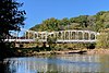
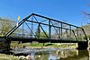
Neshanic Station Lenticular Truss Bridge
|
|
 County Route 667
|
Neshanic Station
|
40°30′34″N 74°43′37″W / 40.5094°N 74.7269°W / 40.5094; -74.7269 (Neshanic Station Lenticular Truss Bridge)
|
|
Rockafellows Mill Bridge
|

|
Rockafellows Mill Road
|
Rockefellows Mills
|
40°31′15″N 74°49′13″W / 40.5207°N 74.8204°W / 40.5207; -74.8204 (Rockafellows Mill Bridge)
|
|
Fink-Type Truss Bridge (demolished)
|
|
Hamden Road/River Road
|
Hamden
|
40°36′14″N 74°54′08″W / 40.6039°N 74.9022°W / 40.6039; -74.9022 (Fink-Type Truss Bridge/Hamden Bridge)
|
|
Main Street Bridge (Clinton, New Jersey)
|

|
Main Street
|
Clinton
|
40°38′10″N 74°54′44″W / 40.6360°N 74.9121°W / 40.6360; -74.9121 (Main Street Bridge (Clinton, New Jersey))
|
| Union Forge Bridge
|

|
Taylor Steelworkers Historic Greenway Trail
|
High Bridge
|
40°40′09″N 74°53′15″W / 40.6692°N 74.8875°W / 40.6692; -74.8875 (Union Forge Bridge)
|
|
Ken Lockwood Gorge Bridge
|

|
Columbia Trail
|
Ken Lockwood Gorge
|
40°41′51″N 74°52′21″W / 40.6976°N 74.8724°W / 40.6976; -74.8724 (Ken Lockwood Gorge Bridge)
|
|
Hoffman's Crossing Road Bridge
|
|
Hoffman's Crossing Road
|
Hoffmans
|
40°42′26″N 74°51′40″W / 40.7071°N 74.8611°W / 40.7071; -74.8611 (Hoffman's Crossing Road)
|
|
Main Street Bridge (Califon, New Jersey)
|

|
Main Street
 County Route 512
|
Califon
|
40°43′14″N 74°50′15″W / 40.7206°N 74.8376°W / 40.7206; -74.8376 (Main Street Bridge (Califon, New Jersey))
|
| Vernoy Road Bridge
|

|
Vernoy Road
|
Tewksbury Township
|
40°44′32″N 74°49′26″W / 40.7423°N 74.8239°W / 40.7423; -74.8239 (Vernoy Road Bridge)
|
| Middle Valley Road Bridge
|
|
Middle Valley Road
|
Middle Valley
|
40°45′41″N 74°49′17″W / 40.7613°N 74.8213°W / 40.7613; -74.8213 (Middle Valley Road Bridge)
|
See also


,_Flemington_vicinity,_Hunterdon_County_(New_Jersey).jpg)


