 | |
| General information | |
| Location |
Linderud,
Bjerke,
Oslo Norway |
| Coordinates | 59°56′26″N 10°50′21″E / 59.94056°N 10.83917°E |
| Owned by | Sporveien |
| Operated by | Sporveien T-banen |
| Line(s) | Grorud Line |
| Distance | 7.8 km (4.8 mi) from Stortinget |
| Connections | 60 Vippetangen — Tonsenhagen |
| Construction | |
| Structure type | At-grade |
| Accessible | Yes |
| History | |
| Opened | 16 October 1966 |
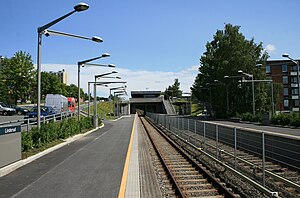
Linderud is a station on Grorud Line of the Oslo Metro located between Vollebekk and Veitvet in Norway. The station is located in the Bjerke borough. Linderud is a residential area, with several tall apartment buildings. The area has a modern shopping centre (formerly known as EPA Centre), located 400 meters (1,300 ft) from the station.
References
External links
![]() Media related to
Linderud stasjon at Wikimedia Commons
Media related to
Linderud stasjon at Wikimedia Commons
| Preceding station |
|
Following station | ||
|---|---|---|---|---|
|
Vollebekk towards
Bergkrystallen
|
Line 4 |
Veitvet towards
Vestli
| ||
| Vollebekk | Line 5 | |||
