Lewisburg Historic District | |
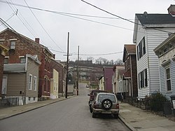
 Scene on Twelfth Street | |
| Location | Roughly bounded by I-75 and the Covington city limits, Covington, Kentucky |
|---|---|
| Coordinates | 39°4′37″N 84°31′23″W / 39.07694°N 84.52306°W |
| Area | 70 acres (28 ha) |
| Built | 1842 |
| Architect | Multiple |
| Architectural style | Late 19th and 20th Century Revivals architecture, Late Victorian, Greek Revival |
| NRHP reference No. | 93001165 [1] |
| Added to NRHP | November 5, 1993 |
Lewisburg Historic District in Covington, Kentucky, United States, is a 70-acre (28 ha) historic district that was listed on the National Register of Historic Places in 1993. [1] At that time, it included 430 buildings deemed to contribute to the historic character of the area, and 46 non-contributing buildings. It is bounded by Interstate 75 on the east and city limits on the southwest and west. [2]
References
- ^ a b "National Register Information System". National Register of Historic Places. National Park Service. March 13, 2009.
- ^ Alexandra Kornilowicz-Weldon (April 29, 1993). "National Register of Historic Places Inventory/Nomination: Lewisburg Historic District". National Park Service. Retrieved March 6, 2017. with 25 photos (see photo captions pages 64-65 in text document)
Categories:
- National Register of Historic Places in Kenton County, Kentucky
- Victorian architecture in Kentucky
- Greek Revival architecture in Kentucky
- Geography of Kenton County, Kentucky
- Historic districts on the National Register of Historic Places in Kentucky
- Buildings and structures in Covington, Kentucky
- Northern Kentucky Registered Historic Place stubs
- Northern Kentucky geography stubs

