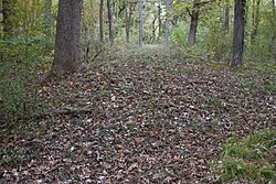
Lewis Mound Group | |
 | |
| Location | Indian Mound Park, McFarland, Wisconsin |
|---|---|
| Coordinates | 43°0′30″N 89°18′0″W / 43.00833°N 89.30000°W |
| NRHP reference No. | 84000809 [1] |
| Added to NRHP | December 15, 1984 |
The Lewis Mound Group (47-Da-74) is a set of prehistoric Native American burial mounds in the village of McFarland, Dane County, Wisconsin, southeast of Madison. Created by late Woodland people overlooking the eastern shore of Lake Waubesa, they include a bear effigy, a hook-shaped mound, and some geometric shapes. They are visible from public trails in Indian Mound Park, which is owned by the village, just west of Indian Mound Middle School. The site was listed on the National Register of Historic Places in 1984. [2] [3]
References
- ^ "National Register Information System". National Register of Historic Places. National Park Service. November 2, 2013.
- ^ Birmingham, Robert A.; Leslie E. Eisenberg (2000). Indian Mounds of Wisconsin. Madison, WI: University of Wisconsin Press. p. 198. ISBN 9780299168742.
- ^ Kittner, Gena. "Plan to Restore Indian Mounds in McFarland". Madison.com. Capital Newspapers. Retrieved February 24, 2019.