Lera
Лера Lerë | |
|---|---|
Village | |
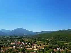
 Panoramic view of the village | |
| Coordinates: 41°06′N 21°10′E / 41.100°N 21.167°E | |
| Country | |
| Region |
|
| Municipality |
|
| Population (2002) | |
| • Total | 122 |
| Time zone | UTC+1 ( CET) |
| • Summer ( DST) | UTC+2 ( CEST) |
| Car plates | BT |
| Website | . |
Lera ( Macedonian: Лера, Albanian: Lerë) is a village in the municipality of Bitola, North Macedonia. It used to be part of the former municipality of Capari.
Demographics
The Albanian population of Lera are Tosks, a subgroup of southern Albanians. [1]
According to the 2002 census, the village had a total of 122 inhabitants. [2] Ethnic groups in the village include: [2]
- Albanians 85
- Macedonians 36
- Others 3
References
- ^ Indogermanische Gesellschaft (1929). Indogermanisches Jahrbuch, Vol. 13. Karl J. Trübner. p. 183. "Monastir (Bitol) auch für das Studium des Alb. geeignet: Ostrec (11 km von Monastir), Zlokućani haben geg., Dihovo, Bratindol, Magarevo, Ramna, Kažani, Dolenci, Lera, Crnovec, Drevenik, Murgašovo tosk. Bevölkerung. Die tosk."
- ^ a b Macedonian Census (2002), Book 5 - Total population according to the Ethnic Affiliation, Mother Tongue and Religion, The State Statistical Office, Skopje, 2002, p. 187.
External links
Wikimedia Commons has media related to
Lera.
