Laurel Hill | |||||||||||
|---|---|---|---|---|---|---|---|---|---|---|---|
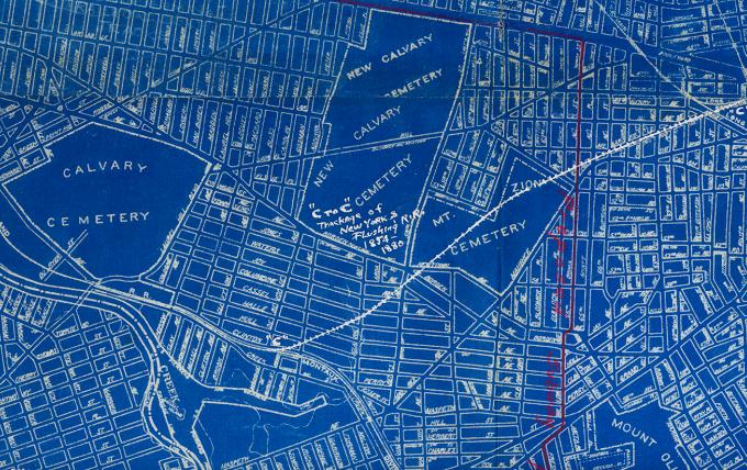
 An 1891 map of the site of the former Laurel Hill Station. | |||||||||||
| General information | |||||||||||
| Location | Clifton Street Long Island City, Queens, New York | ||||||||||
| Coordinates | 40°43′36.38″N 73°55′24.91″W / 40.7267722°N 73.9235861°W | ||||||||||
| Owned by | LIRR | ||||||||||
| Line(s) | Montauk Branch | ||||||||||
| Platforms | 2 side platforms | ||||||||||
| Tracks | 2 | ||||||||||
| History | |||||||||||
| Opened | 1890 | ||||||||||
| Closed | c.1900 | ||||||||||
| Electrified | August 29, 1905 | ||||||||||
| Former services | |||||||||||
| |||||||||||
Laurel Hill was a railroad station on the Lower Montauk Branch of the Long Island Rail Road in Long Island City, New York. It was located on Clifton Street south of Clinton Place, neither of which exist today. Clifton Street is now 46th Street, and is a dead end street that does not reach the vicinity of the Montauk Branch.
Laurel Hill station was located a few blocks west of the point where the former junction between the New York and Flushing Railroad and South Side Railroad of Long Island existed. [1] It was built by the LIRR in 1890. The station was only opened for ten years and closed in 1900. [2] In 1905, the junction was closed for passenger service.[ citation needed] Industrialization of Long Island City and the altering of both street names and street patterns (in this case by the Phelps Dodge Copper Refining and Chemical Plant) have removed all traces of the former station, which is currently along 56th Road (Laurel Hill Boulevard) halfway between 43rd and 48th Streets.
References
- ^ 1924 Long Island Railroad Corporate Blueprint (Arrt's Arrchives)
- ^ "LIRR Station History (TrainsAreFun.com)". Archived from the original on 2017-05-26. Retrieved 2011-06-14.
External links
|
| This Queens train station–related article is a stub. You can help Wikipedia by expanding it. |
- Former Long Island Rail Road stations in New York City
- Railway stations in Queens, New York
- Railway stations in the United States opened in 1890
- Railway stations closed in 1900
- 1890 establishments in New York (state)
- 1900 disestablishments in New York (state)
- Demolished railway stations in the United States
- Railway stations in the United States closed in the 1900s
- New York City railway station stubs
- Queens, New York building and structure stubs