Laton, Kansas | |
|---|---|
| Coordinates: 39°17′08″N 99°04′36″W / 39.28556°N 99.07667°W | |
| Country | United States |
| State | Kansas |
| County | Rooks |
| Elevation | 2,073 ft (632 m) |
| Population | |
| • Total | 0 |
| Time zone | UTC-6 ( CST) |
| • Summer ( DST) | UTC-5 (CDT) |
| Area code | 785 |
| GNIS ID | 484596 [1] |


Laton is a ghost town in Corning Township, Rooks County, Kansas, United States. [1]
History
Eagle Creek was issued a post office in 1878. In 1884 the post office name was changed to Laton before being discontinued in 1904. [2] In addition to the post office Laton had a school, store, cream station, garage, blacksmith shop, and telephone office. [3] The population in 1910 was 30. [4]
The Midland Trail (Red Line Highway) passed thru Laton on its initial route in 1914. The creation of U.S Route 40N (US-24) to the north and K-18 highway to the south by-passed Laton. [5]
Laton School District R-5, Rooks County, Kansas was disorganized in 1962. [6] There is nothing left of Laton.
References
- ^ a b "Laton, Kansas", Geographic Names Information System, United States Geological Survey, United States Department of the Interior
- ^ "Kansas Post Offices, 1828-1961". Kansas Historical Society. Retrieved 2017-12-05.
- ^ "Rooks County Historical Society", Plainville Times, 3 July 1975, p.4
- ^ Blackmar, Frank Wilson (1912). Kansas: A Cyclopedia of State History, Volume 2, Chicago: Standard Publishing Company, p. 107
- ^ "THE RED LINE", Plainville Times, 16 July 1914, p.1
- ^ "TO WHOM IT MAY CONCERN", The Natoma Luray Independent, 19 July 1962, p.5
Municipalities and communities of
Rooks County, Kansas, United States | ||
|---|---|---|
| Cities | 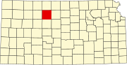 | |
|
Unincorporated communities | ||
| Ghost towns | ||
| Townships | ||
| Footnotes | †This community is designated a
Census-Designated Place (CDP) by the
United States Census Bureau. | |
|
| This article about a location in Rooks County, Kansas is a stub. You can help Wikipedia by expanding it. |