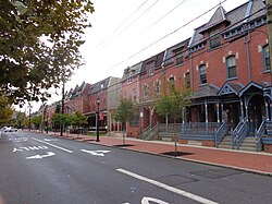
Lanning Square | |
|---|---|
 Row houses in Lanning Square | |
| Country | United States |
| State | New Jersey |
| County | Camden |
| City | Camden |
| Area code | 856 |
Lanning Square is a neighborhood in Camden, New Jersey. It is named for Samuel Laning (1828–1830), the first mayor of Camden. According to the 2000 U.S. Census, Lanning Square has a population of 3,989. [1] [2] The neighborhood, sometimes known as Cooper-Lanning, or Cooper Plaza-Lanning Square, is home to Cooper University Hospital [3] and the Coriell Institute for Medical Research. A planned station called Cooper-Campbell for the proposed Glassboro–Camden Line light rail system would stop in the neighbourhood at Haddon Avenue and South 9th Street west of the North-South Freeway. [4]
References
- ^ "Lanning Square". Camconnect.org. Retrieved February 4, 2012.
- ^ "Cooper Plaza and Lanning Square Neighborhoods". www.livecamden.org. Retrieved June 29, 2014.
- ^ Lindsay, Milton (August 15, 2012). "Delivering Camden from the Brink – Next City". Nextcity.org. Retrieved June 29, 2014.
- ^ "Stations" (PDF). www.glassborocamdenline.com. Retrieved June 6, 2014.
External links
39°56′22″N 75°07′05″W / 39.939474°N 75.118051°W
