| Landsöhr Castle | |
|---|---|
Burg Landsöhr, Burg Landseer, Bertaburg | |
| Bad Boll | |
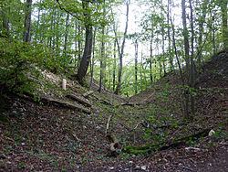
 The hollows on the
hill spur | |
| Coordinates | 48°37′24″N 9°37′38″E / 48.623265°N 9.627317°E |
| Type | hill castle, spur castle |
| Code | DE-BW |
| Height | 739.2 m above sea level (NHN) |
| Site information | |
| Condition | burgstall (no above-ground ruins) |
| Site history | |
| Built | first recorded in 1502 |
Landsöhr Castle ( German: Burg Landsöhr), also called Landseer Castle (Burg Landseer) or Bertaburg, is a lost spur castle on a northern spur, 739.2 m above sea level (NHN), of the Kornberg [1] near Bad Boll in the county of Göppingen in Baden-Württemberg.
The castle was probably built during the Celtic period as a refuge castle. The present burgstall only consists of two hollows between which the castle was probably located.
In the 12th century Berta von Boll, a sister of King Conrad III, is supposed to have had her dower seat here. [2]
References
- ^ Map services of the Federal Agency for Nature Conservation
- ^ Bad Boll 2013 at stauferstelen.net, retrieved 13 December 2013.
Literature
- Konrad Albrecht Koch: Burgenkundliche Beiträge zum Oberamt Göppingen. In: Blätter des Schwäbischen Albvereins. 1926.
- Hartwig Zürn: Boll. In: Die vor- und frühgeschichtlichen Geländedenkmale und die mittelalterlichen Burgstellen der Kreise Göppingen und Ulm. 1961.
- Günter Schmitt: Landsöhr (Bertaburg). In: Derselbe: Burgenführer Schwäbische Alb, Band 1 – Nordost-Alb: Wandern und entdecken zwischen Aalen und Aichelberg. Biberacher Verlagsdruckerei, Biberach an der Riß, 1988, ISBN 3-924489-39-4, pp. 321–326.
External links


