Sächsische Schweiz-Osterzgebirge | |
|---|---|
 Coat of arms | |
|
| |
| Country | Germany |
| State | Saxony |
| Capital | Pirna |
| Government | |
| • District admin. | Michael Geisler ( CDU) |
| Area | |
| • Total | 1,654 km2 (639 sq mi) |
| Population (31 December 2022)
[1] | |
| • Total | 246,204 |
| • Density | 150/km2 (390/sq mi) |
| Time zone | UTC+01:00 ( CET) |
| • Summer ( DST) | UTC+02:00 ( CEST) |
| Vehicle registration | PIR, DW, FTL, SEB |
| Website |
www |
Saxon Switzerland-Eastern Ore Mountains ( German: Sächsische Schweiz-Osterzgebirge) is a district ( Kreis) in Saxony, Germany. It is named after the mountain ranges Saxon Switzerland and Eastern Ore Mountains.
History
The district was established by merging the former districts of Sächsische Schweiz and Weißeritzkreis as part of the district reform of August 2008.
Geography

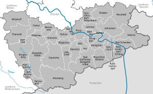
The district is located between Dresden and the Czech Republic. In the southwestern part of the district the easternmost part of the Ore Mountains (″Erzgebirge") is found, the southeastern part of the district is named Saxon Switzerland, which is part of the Elbe Sandstone Mountains. The main river of the district is the Elbe. The district borders (from the west and clockwise) the districts of Mittelsachsen and Meißen, the urban district Dresden, the district of Bautzen, and the Czech Republic.
Towns and municipalities
| Towns | Municipalities | ||
|---|---|---|---|
Transport
The district owns the Regionalverkehr Sächsische Schweiz-Osterzgebirge, a transport company that provides bus, ferry and tram services to the district.
See also
References
- ^ "Einwohnerzahlen nach Gemeinden als Excel-Arbeitsmappe" (XLS) (in German). Statistisches Landesamt des Freistaates Sachsen. 2024.
External links
![]() Media related to
Landkreis Sächsische Schweiz-Osterzgebirge at Wikimedia Commons
Media related to
Landkreis Sächsische Schweiz-Osterzgebirge at Wikimedia Commons
- Official website (German)
| Urban districts | |
|---|---|
| Rural districts | |
| Former urban districts | |
| Former rural districts | |
50°54′N 13°50′E / 50.900°N 13.833°E
| International | |
|---|---|
| National | |