| Lake of Sainte-Croix | |
|---|---|
| Lac de Sainte-Croix ( French) | |
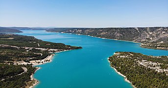
 The lake seen from the northeast, with the Pont du Galetas at the bottom, on the border between Var and Alpes-de-Haute-Provence | |
 Lake of Sainte-Croix | |
| Location | Var/ Alpes-de-Haute-Provence |
| Coordinates | 43°45′49″N 6°11′2″E / 43.76361°N 6.18389°E |
| Type | Reservoir |
| Primary inflows | Verdon |
| Primary outflows | Verdon |
| Catchment area | 1,591 km2 (614 sq mi) |
| Basin countries | France |
| Surface area | 22 km2 (8.5 sq mi) |
| Max. depth | 93 m (305 ft) |
| Water volume | 760×106 m3 (27×109 cu ft) |
| Surface elevation | 477 m (1,565 ft) |
| Settlements | Les Salles-sur-Verdon, Sainte-Croix-du-Verdon, Bauduen |
The Lake of Sainte-Croix ( French: Lac de Sainte-Croix, pronounced [lak də sɛ̃tkʁwa]) is a reservoir in Southern France that was formed by the construction, between 1971 and 1974 (when it was put into service), [1] of a reinforced-concrete arch dam, the Sainte-Croix Dam. It marks the departmental border between Var to the southeast and Alpes-de-Haute-Provence to the northwest.
Geography
The reservoir is fed by the Verdon river, at the outlet of the Verdon Gorge. It holds a maximum of 761 million cubic metres of water. The dam, which generates 142 million kWh of electricity per year, is 94 metres high, 7.5 metres thick at its base and 3 metres thick at its crest.
The village of Les Salles-sur-Verdon stands by the lake; it was rebuilt on the shore after the original lower village was destroyed to make room for the reservoir. Other villages around the lake are Bauduen and Sainte-Croix-du-Verdon. The lake comprises a sole island, the Île de Costebelle (Island of Costebelle), part of the commune of Les Salles-sur-Verdon.
-
 The Lake of Sainte-Croix seen from the outlet of the Verdon Gorge
 -
 Les Salles-sur-Verdon seen from the southeast
 -
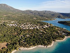 Les Salles-sur-Verdon by the lake
 -
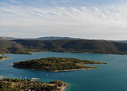 The Île de Costebelle


.jpg)
References
- ^ L’histoire de la vallée, www.stecroixduverdon-tourisme.fr (in French).
External links
-
 Media related to
Lac de Sainte-Croix at Wikimedia Commons
Media related to
Lac de Sainte-Croix at Wikimedia Commons