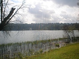
| Lake Zirahuén | |
|---|---|
 Lake Zirahuén | |
| Location | Santa Clara del Cobre, Michoacán, Mexico |
| Coordinates | 19°27′N 101°44′W / 19.450°N 101.733°W |
| Type | endorheic lake |
Lake Zirahuén is a small endorheic lake in the municipality of Santa Clara del Cobre in Michoacán, Mexico. It is a deep mountain lake with a sandy bottom that is partially covered with mud. [1] It covers an area of 970 hectares (2,400 acres) and has a volume of 0.216 cubic kilometres (0.052 cu mi). [2]
At times Lake Zirahuén has been part of an open and continuous hydrological system together with Lake Cuitzeo and Lake Pátzcuaro, draining into the Lerma River. Today it is a closed basin like Lakes Cuitzeo and Pátzcuaro, although ecologists consider it a sub-basin of the Lerma- Chapala basin. [3]
The Zirahuén allotica ( Allotoca meeki), a Goodeid fish, is endemic to Lake Zirahuén. [4]
References
- ^ "Allotoca meeki, Zirahuen allotica (Alvarez, 1959)", Fishbase. Accessed November 15, 2009. [1] Archived 2011-07-21 at the Wayback Machine
- ^ "62. PÁTZCUARO Y CUENCAS ENDORRÉICAS CERCANAS". Regiones hidrológicas prioritarias. Mexico: Comisión Nacional para el Conocimiento y Uso de la Biodiversidad. 19 December 2008. Retrieved 27 July 2016.
- ^ "Descripción de la cuenca", Recuperación Ambiental del Lago de Pátzcuaro". Accessed October 18, 2009. [2] Archived 2009-04-16 at the Wayback Machine
- ^ "Allotoca meeki, Zirahuen allotica (Alvarez, 1959)", Fishbase. Accessed November 15, 2009. [3] Archived 2011-07-21 at the Wayback Machine

