| Lake Cascade State Park | |
|---|---|
IUCN category V (protected landscape/seascape) | |
 | |
| Location | Valley County, Idaho, United States |
| Nearest city | Cascade, Idaho |
| Coordinates | 44°31′26″N 116°03′04″W / 44.524°N 116.051°W [1] |
| Area | 500 acres (200 ha) [1] |
| Elevation | 4,828 ft (1,472 m) [1] |
| Designation | Idaho state park |
| Established | 1999 [2] |
| Administrator | Idaho Department of Parks and Recreation |
| Website | Lake Cascade State Park |
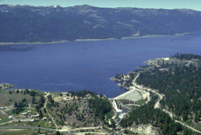
Lake Cascade State Park is a public recreation area consisting of multiple units totaling 500 acres (200 ha) around Lake Cascade, an impoundment of the North Fork of the Payette River that covers 27,000 acres (11,000 ha) [3] in Valley County, Idaho, United States. The state park includes 279 individual campsites in 10 developed campgrounds, six boat ramps, and opportunities for hiking, fishing, ice fishing, skiing, and bird watching. [1]
Wildlife
This state park is home to waterfowl, deer, rainbow trout, raccoon, eagles, black bear, owls, fox, songbirds, badger, coho salmon, elk, cougar, hawks, smallmouth bass, perch, grizzly bear and skunk.
See also
References
- ^ a b c d "Lake Cascade State Park". Idaho Parks and Recreation. Retrieved May 28, 2012.
- ^ "History: State Lands in Idaho". Idaho Museum of Natural History. Retrieved October 17, 2018.
- ^ "Cascade Reservoir (Lake Cascade)". Idaho Department of Fish and Game. Retrieved November 19, 2018.
External links
- Lake Cascade State Park Idaho Parks and Recreation
- Lake Cascade State Park Units Map Idaho Parks and Recreation

