Laheda Parish
Laheda vald | |
|---|---|

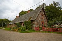
Tilsi manor dairy | |
 Laheda Parish within Põlva County. | |
| Country |
|
| County |
|
| Administrative centre | Tilsi |
| Area | |
| • Total | 91.47 km2 (35.32 sq mi) |
| Population (01.01.2009) | |
| • Total | 1,355 |
| • Density | 15/km2 (38/sq mi) |
| Website | www.laheda.ee |
Laheda Parish ( Estonian: Laheda vald) was a rural municipality of Estonia, in Põlva County. It had a population of 1,355 on 1 January 2009 and an area of 91.47 km². [1]
Ridali Airfield was located in Laheda Parish.
Settlements
- Villages
Himma - Joosu - Lahe - Mustajõe - Naruski - Pragi - Roosi - Suurküla - Tilsi - Vana-Koiola - Vardja
References
- ^ "Population figure and composition". Statistics Estonia. Retrieved 27 January 2010.
External links
- Official website (in Estonian)
57°58′7″N 27°0′2″E / 57.96861°N 27.00056°E

