This article needs additional citations for
verification. (July 2016) |
Lehbab
لهباب | |
|---|---|
Community | |
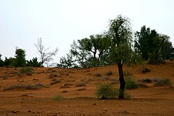
 Desert in Lehbab | |
| Coordinates: 25°03′35″N 55°36′30″E / 25.059745°N 55.608416°E | |
| Country | United Arab Emirates |
| Emirate | Dubai |
| City | Dubai |
| Area | |
| • Total | 97.0 km2 (37.5 sq mi) |
| Population | |
| • Total | 4,490 |
| • Density | 46/km2 (120/sq mi) |
| Community number | 731, 831 |
Lehbab (Arabic|لهباب), is a community of the Emirate of Dubai, in the United Arab Emirates. It is located in the Sector 7 and Sector 8 in South East Dubai.
Territory
The territory of the community occupies an area of 97.0 km2 [1] which develops in a non-urban area in eastern Dubai , on the border with the Emirate of Sharjah.
The community is divided into two subcommunities Lehbab First (community 731) in the east Lehbab Second (community 831) in the west
The area is bounded on the west by Umm Al Mo'meneen and Le Hemaira, on the south by Margham and Nazwah on the east, by the communities of Al Meryal and to the north by the community of Mereiyeel, Enkhali and Al Wohoosh. [2] [3]
The area is not currently served by the Dubai Metro. Center from Dubai-Hatta Road (E 44). [4]
Notes
- ^ Dubai Statistics Center. "Distribution of Estimated Population & Population Density (person/km2) by Sector and Community - Emirate of Dubai (2021)" (PDF). Retrieved 15 September 2022.
- ^ Interactive map of Lehbab 1
- ^ Interactive map of Lehbab 2
- ^ "RTA Journey Planner". Retrieved 26 March 2023.
Bibliography
- Dubai: The Complete Residents' Guide. Explorer Publishing & Distribution, 2006. June 2006. ISBN 9789768182760.