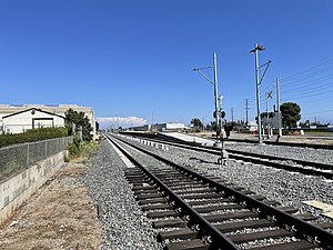
 La Verne station under construction in August 2023 | |||||||||||||
| General information | |||||||||||||
| Coordinates | 34°05′51″N 117°46′08″W / 34.0974°N 117.7688°W | ||||||||||||
| Owned by | Los Angeles County Metropolitan Transportation Authority | ||||||||||||
| Platforms | 1 island platform | ||||||||||||
| Tracks | 2 | ||||||||||||
| Construction | |||||||||||||
| Accessible | Yes | ||||||||||||
| Other information | |||||||||||||
| Status | Under construction | ||||||||||||
| History | |||||||||||||
| Opening | 2025 | ||||||||||||
| Future services | |||||||||||||
| |||||||||||||
| |||||||||||||
| Location | |||||||||||||
|
| |||||||||||||
La Verne station is an under construction light rail station in the Los Angeles Metro Rail system. [1] It is currently under construction as part of the Foothill Extension Project and is slated to open in early 2025. [2]
The station is located near the intersection of Arrow Highway and E Street along the Pasadena Subdivision right-of-way in La Verne, California. The University of La Verne is northwest of the station, and Fairplex is one block to the south.
References
- ^ Broverman, Neal (August 21, 2012). "Plans Released for Gold Line Train to San Bernardino County". Curbed Los Angeles. Vox Media Inc. Archived from the original on August 28, 2012. Retrieved January 7, 2015.
- ^ @numble (November 27, 2023). "October 2023 status report for LA Metro's Foothill Gold Line Extension. 79.4% as of 10/31/23, +~1.4% since 9/30/23. Forecast completion on 12/14/24" ( Tweet). Retrieved November 28, 2023 – via Twitter.