La Mott
Camp Town | |
|---|---|
 Corner, Willow and Sycamore avenues, La Mott, Pennsylvania, 2012 | |
 La Mott Location of La Mott in Pennsylvania  La Mott La Mott (the United States) | |
| Coordinates: 40°04′04″N 75°08′26″W / 40.06778°N 75.14056°W | |
| Country | United States |
| State | Pennsylvania |
| County | Montgomery |
| Township | |
| Commissioner | Harvey Portner |
| Area | |
| • Total | .261 sq mi (0.68 km2) |
| • Land | .261 sq mi (0.68 km2) |
| • Water | 0.00 sq mi (0.0 km2) |
| Elevation | 230 ft (70 m) |
| Population (2010) | |
| • Total | 3,554 |
| • Density | 14,000/sq mi (5,300/km2) |
| Time zone | UTC-5 ( Eastern Standard Time) |
| • Summer ( DST) | UTC-4 ( Eastern Daylight Time) |
| Area codes | 215, 267 and 445 |
| Website |
66 |
| Official name | Village of La Mott |
| Designated | June 1973 |
La Mott is an unincorporated residential community located within Cheltenham Township, Montgomery County, Pennsylvania, United States. Its name honors the leading 19th Century abolitionist and suffragist, Lucretia Mott, who resided in the neighborhood.
Of the sixty-five locations in the continental United States named Mott, this is the only community named "La Mott." It borders Philadelphia, along Cheltenham Avenue, and has been assigned the ZIP code of 19027.
History
The name of this town honors Lucretia Mott, who lived here from the 1850s until her death in 1880. [1] Her house, Roadside, which was demolished in 1911, was a major stop on the Underground Railroad.
Formerly known as Camptown (or "Camp Town"), La Mott was the site of Camp William Penn, the first federal training site for Black soldiers during the American Civil War.
Gallery
-
 La Mott AME Church
 -
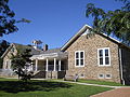 La Mott Community Center and Free Library
 -
 Residence, Old York Road
 -
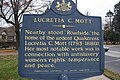 Sign at the site of former Lucretia Mott House
 -
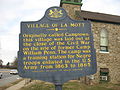 La Mott historical marker


See also
References
- ^ "Cheltenham Township: La Mott Historic District". Retrieved October 17, 2020.
External links
Cheltenham Township, Montgomery County, Pennsylvania | ||
|---|---|---|
Founded 1682 | ||
| Communities |     | |
| Education | ||
| National Historic Sites | ||
| People | ||
| See also | ||
| Historical railroads | ||
| Regional rail lines | ||
| Regional rail stations | ||
| SEPTA bus routes | ||
| Infrastructure | ||
