La Canourgue | |
|---|---|
 The road through La Canourgue | |
 Coat of arms | |
 La Canourgue  La Canourgue | |
| Coordinates: 44°26′01″N 3°12′56″E / 44.4336°N 3.2156°E | |
| Country | France |
| Region | Occitania |
| Department | Lozère |
| Arrondissement | Mende |
| Canton | La Canourgue |
| Intercommunality | Aubrac Lot Causses Tarn |
| Government | |
| • Mayor (2020–2026) | Claude Malzac [1] |
| Area 1 | 104.29 km2 (40.27 sq mi) |
| Population (2021)
[2] | 2,099 |
| • Density | 20/km2 (52/sq mi) |
| Time zone | UTC+01:00 ( CET) |
| • Summer ( DST) | UTC+02:00 ( CEST) |
| INSEE/Postal code |
48034 /48500 |
| Elevation | 521–1,008 m (1,709–3,307 ft) (avg. 563 m or 1,847 ft) |
| 1 French Land Register data, which excludes lakes, ponds, glaciers > 1 km2 (0.386 sq mi or 247 acres) and river estuaries. | |
La Canourgue (French pronunciation: [la kanuʁɡ]; Occitan: La Canorga) is a commune in the Lozère department in southern France. [3] It is sometimes referred to in French as "La petite Venise lozérienne", the Little Venice of Lozère.
The commune served as a location for the 2006 film A Good Year. [4]
Population
| Year | Pop. | ±% p.a. |
|---|---|---|
| 1968 | 1,719 | — |
| 1975 | 1,850 | +1.05% |
| 1982 | 1,804 | −0.36% |
| 1990 | 1,817 | +0.09% |
| 1999 | 1,922 | +0.63% |
| 2007 | 2,116 | +1.21% |
| 2012 | 2,143 | +0.25% |
| 2017 | 2,161 | +0.17% |
| Source: INSEE [5] | ||
See also
References
- ^ "Répertoire national des élus: les maires" (in French). data.gouv.fr, Plateforme ouverte des données publiques françaises. 13 September 2022.
- ^ "Populations légales 2021". The National Institute of Statistics and Economic Studies. 28 December 2023.
- ^ INSEE commune file
- ^ Postcards from Provence. A Good Year DVD. 2007.
- ^ Population en historique depuis 1968, INSEE
Gallery
-
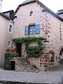 House in La Canourgue
 -
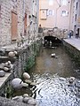 Canal in La Canourgue


Wikimedia Commons has media related to
La Canourgue.
| International | |
|---|---|
| National | |
|
| This Lozère geographical article is a stub. You can help Wikipedia by expanding it. |