This article may be in need of reorganization to comply with Wikipedia's
layout guidelines. (September 2017) |
| Kullu Valley | |
|---|---|
| Kulu Valley | |
 Kullu Valley | |
| Geology | |
| Type | River Valley |
| Geography | |
| Location | Himachal Pradesh in India |
| Population centers | Kullu |
| Coordinates | 31°57′28″N 77°6′34″E / 31.95778°N 77.10944°E |
| Rivers | Beas River |
Kullu Valley is a broad open valley in Himachal Pradesh, India, formed by the Beas River between Manali and Larji. [1] This valley is famous for its temples, beauty and its majestic hills covered with pine and deodar forest and sprawling apple orchards. The course of the Beas river presents a succession of magnificent, clad with forests of deodar, towering above trees of pine on the lower rocky ridges. Kullu valley is sandwiched between the Pir Panjal, Lower Himalayan and Great Himalayan Ranges. [2] Ski touring is a sport growing in popularity in the Himilayan peaks surrounding the valley. [3]
Economy
See Economy section in Kullu district.
Tourism
For places of interest, festivals, and outdoor sports in the Kullu valley, see Attractions section in Kullu district.
Further reading
See Further reading section in Kullu district.
Gallery
-
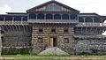 Naggar Castle in Kullu valley
 -
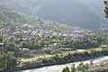 Kullu valley with river Beas
 -
 Autumn in Kullu Valley
 -
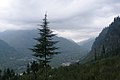
 View of Himalayas from Beas river valley in Kullu
 -
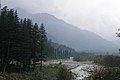 Beas River in September
 -
 Panoramic view
 -
 Naggar


References
- ^ CIL. "Exhibition - Malana - A Lost Utopia in the Himalayas". ignca.nic.in. Archived from the original on 3 March 2016. Retrieved 20 September 2017.
- ^ PRADESH, HIMACHAL. "Mythological references and evidances - Kullu District Official Website, Himachal Pradesh". himachal.gov.in. Retrieved 20 September 2017.
- ^ Spooner, Campbell (2002). Ski Touring India's Kullu Valley. Canada: Alpine Touring Publishing. p. 160. ISBN 0958108609.
|
| This Himachal Pradesh location article is a stub. You can help Wikipedia by expanding it. |