| Kintampo | |
|---|---|
 | |
 | |
|
| |
| Location | Kintampo, Ghana |
| Coordinates | 8°5′22.75″N 1°41′50.60″W / 8.0896528°N 1.6973889°W |
| Type | Multi-step |
| Number of drops | 3 |
| Longest drop | 25 metres (82 ft) |
| Watercourse | Pumpum |
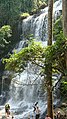
Kintampo waterfalls is one of Ghana' highest waterfalls located in Bono East. It was formerly known as Sanders Falls during the colonial days. [1] It is located on the Pumpum river, a tributary of the Black Volta, about 4 kilometres (2.5 mi) north of the Kintampo municipality, on the Kumasi– Tamale road. It is just after the Falls Rest Stop when moving Northwards, on the right side of the road. This waterfall is hidden in the forest and formed by three main drops, with the longest measuring 25 metres (82 ft), followed by a number of steps and cascades, and the river, which falls about 70 metres (230 ft). [2] [3] [4] [5] [6]
History
The waterfalls was designated in 1992 as a tourist site, after it was discovered in the 18th century. [1]
Incidents
On 20 March 2017, 28 people were killed and others injured after a large tree fell on them at the waterfalls, following a storm. [7] Reportedly, the police declared that 22 persons were rescued. [8] After the incident, the Ghanaian Ministry of Tourism, Arts and Culture closed the falls, to undertake a security and safety assessment, as well as reconstruction. [9] Before reopening to the public in 2019, a canopy walkway was constructed. [10]
Description
The water flows from the Pumpum River, a tributary of the Black Volta which takes its source from Pumpumatifi. The falls has three stages. The initial two stages can be reached easily because the way is levelled. The third stage has about 173 stairs down and about 151 stairs up. The water flows from a distance of about 25 metres. [1]
Facilities
The waterfalls currently has car park, stairs, receptive center and a canopy walkway. [1]
Gallery
-
 Main drop (front view)
 -
 Main drop (lateral view)
 -
 Staircase leading to the waterfall


References
- ^ a b c d "Kintampo Waterfalls". Graphic Online. Retrieved 2022-05-22.
- ^ "Kintampo Waterfall". ghana.photographers-resource.com.
- ^ "Kintampo Waterfalls". Ghana Tourism Authority. Archived from the original on 2012-06-17.
- ^ "Kintampo Waterfalls". Wildlife and Nature Reserves. ghanaexpeditions.com. Archived from the original on 2016-08-25. Retrieved 2012-10-30.
- ^ "tourism attractions". about this district. Kintampo North Municipal Assembly.
- ^ WhiteOrange. "Brong Ahafo". Ghana Tourism Authority. Archived from the original on 2020-12-06. Retrieved 2020-01-31.
- ^ "Ghana waterfall: Many dead in Kintampo freak tree accident". BBC News. 20 March 2017. Retrieved 21 March 2017.
- ^ "Falling tree kills at least 18 at Ghana waterfall". Reuters. 20 March 2017. Archived from the original on 20 March 2017. Retrieved 21 March 2017.
- ^ "Kintampo waterfalls closed down indefinitely | Ghana News". citifmonline.com. Archived from the original on 2017-03-21.
- ^ Tosogha (2020-01-22). "Refurbished Kintampo Waterfalls see surge in tourist visits …over 23,000 people visited the site in 2019". Tourism Society of Ghana. Retrieved 2021-01-22.
External links
-
 Media related to
Kintampo Waterfalls at Wikimedia Commons
Media related to
Kintampo Waterfalls at Wikimedia Commons