Ketzin | |
|---|---|
Town in The
Havelland (district) Located in Brandenburg Germany | |
| Stadt Ketzin | |
 Town Hall | |
 Coat of arms | |
 Ketzin In
Germany | |
 Ketzin In
Havelland (district) | |
| Coordinates: 52°28′11″N 12°50′42″E / 52.46972°N 12.84500°E | |
| Time zone | UTC+01:00 ( Central European Time) |
| • Summer ( DST) | Central European Summer Time |
| Vehicle registration | HVL |
| Website | https://www-ketzin-de.translate.goog/?_x_tr_sl=auto&_x_tr_tl=en&_x_tr_hl=en&_x_tr_pto=wapp |
Ketzin (German: [kɛˈt͡siːn] ⓘ, official name: Ketzin/Havel) is a town in the Havelland district, in Brandenburg, Germany. It is situated on the river Havel, 17 km northwest of Potsdam, and 40 km west of Berlin.
History
|
| This section needs expansion. You can help by
adding to it. (May 2010) |
Demography
-
 Development of Population since 1875 within the Current Boundaries (Blue Line: Population; Dotted Line: Comparison to Population Development of Brandenburg state; Grey Background: Time of Nazi rule; Red Background: Time of Communist rule)
 -
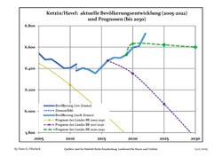 Recent Population Development and Projections (Population Development before Census 2011 (blue line); Recent Population Development according to the Census in Germany in 2011 (blue bordered line); Official projections for 2005-2030 (yellow line); for 2017-2030 (scarlet line); for 2020-2030 (green line)
|
|
|
Geography
The town counts 6 Ortsteile (civil parishes): Etzin, Falkenrehde, Knoblauch, Paretz, Tremmen and Zachow.
Transport
The Ketzin Cable Ferry, a vehicular cable ferry, crosses the Havel between Ketzin and Schmergow.
References
- ^ Detailed data sources are to be found in the Wikimedia Commons. Population Projection Brandenburg at Wikimedia Commons
External links
![]() Media related to
Ketzin/Havel at Wikimedia Commons
Media related to
Ketzin/Havel at Wikimedia Commons
Towns and municipalities in
Havelland | ||
|---|---|---|
 | ||
| International | |
|---|---|
| National | |
| Geographic | |
|
| This Brandenburg location article is a stub. You can help Wikipedia by expanding it. |