Johnsonburg, New Jersey | |
|---|---|
 Frelinghuysen Township Hall | |
 Johnsonburg Location in
Warren County  Johnsonburg Location in
New Jersey  Johnsonburg Location in the United States | |
| Coordinates: 40°57′54″N 74°52′41″W / 40.965072°N 74.878177°W [1] [2] | |
| Country | |
| State | |
| County | Warren |
| Township | Frelinghuysen |
| Area | |
| • Total | 1.07 sq mi (2.76 km2) |
| • Land | 1.06 sq mi (2.76 km2) |
| • Water | 0.00 sq mi (0.00 km2) 0.00% |
| Elevation | 574 ft (175 m) |
| Population | |
| • Total | 381 |
| • Density | 357.75/sq mi (138.12/km2) |
| Time zone | UTC−05:00 ( Eastern (EST)) |
| • Summer ( DST) | UTC−04:00 ( EDT) |
| ZIP Code | 07846 - Johnsonburg
[6] |
| Area code | 908 |
| FIPS code | 34-36150 [1] [7] [8] |
| GNIS feature ID | 02584004 [1] [9] |
Johnsonburg is an unincorporated community and census-designated place (CDP) [10] located within Frelinghuysen Township in Warren County, in the U.S. state of New Jersey, [11] that was created as part of the 2010 United States Census. [12] [13] [14] As of the 2020 Census, the CDP's population was 381, [15] up from 101 in the 2010 Census. [16]
History
Johnsonburg originated as an important stagecoach stop. An east-west route carried mail from Dover, New Jersey to Stroudsburg, Pennsylvania, and a north-south route carried mail from Albany, New York to Philadelphia, Pennsylvania. Both routes crossed at right angles at this location, and a post office and tavern were built. The tavern became an important meeting place, and elections and caucuses were held there. [17] [18]
A jail was erected in 1753, and the community became known as "Log Gaol" (log jail). Located at the time in Sussex County, Log Gaol was the county seat from 1753 to 1765. [19] The county court was also located at Log Gaol. [18]
By 1882, the population had grown to 300. Johnsonburg had a post office, a large glove factory, and a "good local trade". [20]
The Delaware, Lackawanna and Western Railroad ('DLW') opened Johnsonburg station in Johnsonburg in 1911, along a mainline running between Hoboken, New Jersey and Buffalo, New York. The railway was important to local dairy farmers, who shipped their products east to Newark and New York City. The historic Lackawanna passenger station has been demolished. [18]
Geography
According to the United States Census Bureau, the CDP had a total land area of 0.196 square miles (0.509 km2), and no water area. [1] [2]
Demographics
| Census | Pop. | Note | %± |
|---|---|---|---|
| 2000 | 59 | — | |
| 2010 | 101 | 71.2% | |
| 2020 | 381 | 277.2% | |
| U.S. Decennial Census
[21] 2010 [16] 2020 [5] | |||
2010 census
The 2010 United States census counted 101 people, 42 households, and 32 families in the CDP. The population density was 514.3 per square mile (198.6/km2). There were 45 housing units at an average density of 229.2 per square mile (88.5/km2). The racial makeup was 100.00% (101) White, 0.00% (0) Black or African American, 0.00% (0) Native American, 0.00% (0) Asian, 0.00% (0) Pacific Islander, 0.00% (0) from other races, and 0.00% (0) from two or more races. Hispanic or Latino of any race were 0.00% (0) of the population. [16]
Of the 42 households, 23.8% had children under the age of 18; 54.8% were married couples living together; 11.9% had a female householder with no husband present and 23.8% were non-families. Of all households, 16.7% were made up of individuals and 4.8% had someone living alone who was 65 years of age or older. The average household size was 2.40 and the average family size was 2.75. [16]
16.8% of the population were under the age of 18, 5.9% from 18 to 24, 23.8% from 25 to 44, 37.6% from 45 to 64, and 15.8% who were 65 years of age or older. The median age was 46.4 years. For every 100 females, the population had 98.0 males. For every 100 females ages 18 and older there were 95.3 males. [16]
Historic district
Johnsonburg Historic District | |
 Armstrong/Blair House | |
| Location | NJ 519 and 661 and adjacent parts of Mott and Allamuchy Roads |
|---|---|
| Area | 163 acres (66 ha) |
| Architectural style | Mid-19th Century, Early Republic |
| NRHP reference No. | 92001386 [22] |
| NJRHP No. | 2750 [23] |
| Significant dates | |
| Added to NRHP | October 15, 1992 |
| Designated NJRHP | September 2, 1992 |
The Johnsonburg Historic District is a 163-acre (66 ha) historic district encompassing the community along County Route 519 (Johnsonburg Road, Dark Moon Road), County Route 661 (Main Street) and adjacent parts of Mott and Allamuchy Roads. It was added to the National Register of Historic Places on October 15, 1992, for its significance in architecture, community development, commerce, industry, and religion. The district includes 74 contributing buildings, 4 contributing sites, 3 contributing structures and 1 contributing object. [24]
The Armstrong/Blair House features Colonial Revival and Greek Revival architecture. The Frelinghuysen Township Hall was formerly the Presbyterian Chapel. It was built in 1851 and features Greek Revival and Federal architecture. The Christian Church is a one-story stone church built c. 1838–1848. The Methodist Episcopal Church was built in 1850 with Gothic Revival architecture. [24] The John Gibbs House is an example of an octagon house. It was built in 1853 and was documented by the Historic American Buildings Survey (HABS) in 1941. [25]
-
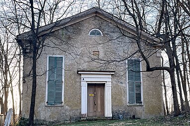 Christian Church
 -
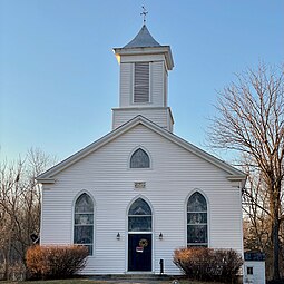 Methodist Episcopal Church
 -
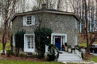 John Gibbs House


See also
References
- ^ a b c d Gazetteer of New Jersey Places, United States Census Bureau. Accessed July 21, 2016.
- ^ a b US Gazetteer files: 2010, 2000, and 1990 , United States Census Bureau. Accessed September 4, 2014.
- ^ "ArcGIS REST Services Directory". United States Census Bureau. Retrieved October 11, 2022.
- ^ U.S. Geological Survey Geographic Names Information System: Johnsonburg Census Designated Place, Geographic Names Information System. Accessed June 3, 2013
- ^ a b Census Data Explorer: Johnsonburg CDP, New Jersey, United States Census Bureau. Accessed June 15, 2023.
- ^ Look Up a ZIP Code for Johnsonburg, NJ, United States Postal Service. Accessed June 3, 2013.
- ^ U.S. Census website, United States Census Bureau. Accessed September 4, 2014.
- ^ Geographic codes for New Jersey, Missouri Census Data Center. Accessed June 9, 2023.
- ^ US Board on Geographic Names, United States Geological Survey. Accessed September 4, 2014.
- ^ State of New Jersey Census Designated Places - BVP20 - Data as of January 1, 2020, United States Census Bureau. Accessed December 1, 2022.
- ^ Locality Search, State of New Jersey. Accessed April 18, 2015.
- ^ GCT-PH1 - Population, Housing Units, Area, and Density: 2010 - County -- County Subdivision and Place from the 2010 Census Summary File 1 for Warren County, New Jersey Archived 2020-02-12 at archive.today, United States Census Bureau. Accessed June 4, 2013.
- ^ 2006-2010 American Community Survey Geography for New Jersey, United States Census Bureau. Accessed June 4, 2013.
- ^ New Jersey: 2010 - Population and Housing Unit Counts - 2010 Census of Population and Housing (CPH-2-32), United States Census Bureau, p. III-5, August 2012. Accessed June 4, 2013. "Warren County—Name Changes: Beattystown CDP name corrected from Beatyestown; New CDPs: Allamuchy (formed from part of deleted Allamuchy-Panther Valley CDP), Anderson, Asbury, Blairstown, Brainards, Bridgeville, Broadway, Brookfield, Buttzville, Columbia, Delaware, Delaware Park, Finesville, Great Meadows (formed from part of deleted Great Meadows-Vienna CDP and additional area), Greenwich, Hainesburg, Harmony, Hope, Hutchinson, Johnsonburg, Lopatcong Overlook, Marksboro, Mountain Lake, Mount Hermon, New Village, Panther Valley (formed from part of deleted Allamuchy-Panther Valley CDP), Port Colden, Port Murray, Silver Lake, Stewartsville, Upper Pohatcong, Upper Stewartsville, and Vienna (formed from part of deleted Great Meadows-Vienna and additional area)"
- ^ US 2020 Census Bureau report, Johnsonburg CDP, Warren County, New Jersey
- ^ a b c d e DP-1 - Profile of General Population and Housing Characteristics: 2010 Demographic Profile Data for Johnsonburg CDP, New Jersey Archived 2020-02-12 at archive.today, United States Census Bureau. Accessed June 3, 2013.
- ^ Armstrong, Michael; Armstrong, William C. (2009). Pioneer Families of Northwestern New Jersey. Genealogical Publishing. p. 370. ISBN 9780806346625.
- ^ a b c "History of the Township". Township of Frelinghuysen. Retrieved December 7, 2014.
- ^ "Historic Sites of Warren County" (PDF). Warren County. Archived from the original (PDF) on January 13, 2020. Retrieved December 6, 2014.
- ^ Industries of New Jersey. Historical Publishing Company. 1882. pp. 96. OL 24332547M.
- ^ "Census of Population and Housing". Census.gov. Retrieved June 4, 2016.
- ^ "National Register Information System – (#92001386)". National Register of Historic Places. National Park Service. November 2, 2013.
- ^ "New Jersey and National Registers of Historic Places – Warren County" (PDF). New Jersey Department of Environmental Protection – Historic Preservation Office. September 11, 2023. p. 3.
- ^ a b Bertland, Dennis (January 1992). "National Register of Historic Places Inventory/Nomination: Johnsonburg Historic District". National Park Service. With accompanying 28 photos
- ^ "Gibbs House". Historic American Buildings Survey. 1941.
External links
-
 Media related to
Johnsonburg, New Jersey at Wikimedia Commons
Media related to
Johnsonburg, New Jersey at Wikimedia Commons - Historic American Buildings Survey (HABS) No. NJ-440, " Gibbs House, Greendell Road, Johnsonburg, Warren County, NJ", 1 photo, 10 measured drawings, 3 data pages
- "Logg Gaol". Historical Marker Database.
Municipalities and communities of
Warren County, New Jersey, United States | ||
|---|---|---|
| Boroughs |  | |
| Towns | ||
| Townships | ||
| CDPs |
| |
|
Other unincorporated communities | ||