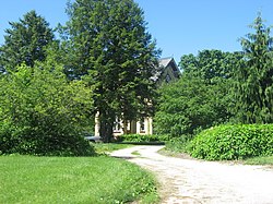
John and Cynthia Garwood Farmstead | |
 John and Cynthia Garwood Farmstead, June 2013 | |
| Location | 5600 Small Rd., west of LaPorte, Center Township, LaPorte County, Indiana |
|---|---|
| Coordinates | 41°36′40″N 86°48′31″W / 41.61111°N 86.80861°W |
| Area | 6.5 acres (2.6 ha) |
| Built | c. 1866, c. 1930 |
| Architectural style | Italian Villa |
| NRHP reference No. | 12000334 [1] |
| Added to NRHP | June 15, 2012 |
John and Cynthia Garwood Farmstead is a historic home and farm located in Center Township, LaPorte County, Indiana. The house was built about 1866, and is a tall 2+1⁄2-story, three-bay, Italian Villa style brick dwelling. It has a gabled-ell form with a center tower. Also on the property are the contributing gambrel-roofed barn (c. 1930), milk house (c. 1930), and silo (c. 1930). [2]: 3
It was listed on the National Register of Historic Places in 2012. [1]
References
- ^ a b "National Register of Historic Places Listings". Weekly List of Actions Taken on Properties: 6/11/12 through 6/15/12. National Park Service. 2012-06-22.
- ^ "Indiana State Historic Architectural and Archaeological Research Database (SHAARD)" (Searchable database). Department of Natural Resources, Division of Historic Preservation and Archaeology. Retrieved 2016-05-01. Note: This includes Kurt West Garner (November 2010). "National Register of Historic Places Inventory Nomination Form: John and Cynthia Garwood Farmstead'" (PDF). Retrieved 2016-05-01..


