Jerome, Kansas | |
|---|---|
 | |
 Jerome  Jerome | |
| Coordinates: 38°44′50″N 100°31′38″W / 38.74722°N 100.52722°W [1] | |
| Country | United States |
| State | Kansas |
| County | Gove |
| Elevation | 2,510 ft (770 m) |
| Population | |
| • Total | 0 |
| Time zone | UTC-6 ( CST) |
| • Summer ( DST) | UTC-5 (CDT) |
| Area code | 785 |
| GNIS ID | 482217 [1] |
Jerome is a ghost town in Jerome Township, Gove County, Kansas, United States. [1]
History
Jerome was issued a post office in 1886. The post office was discontinued in 1943. [2] Jerome was once a flourishing town with a hotel, a newspaper (the Smoky Hill Globe), several stores, and professionals. By 1910 its population has declined to 12 [3].
References
- ^ a b c d "Jerome, Kansas", Geographic Names Information System, United States Geological Survey, United States Department of the Interior
- ^ "Kansas Post Offices, 1828-1961". Kansas Historical Society. Retrieved 2018-01-05.[ permanent dead link]
- ^ "Jerome - KS-Cyclopedia - 1912". www.ksgenweb.org. Retrieved 2024-01-23.
Further reading
External links
Municipalities and communities of
Gove County, Kansas, United States | ||
|---|---|---|
| Cities | 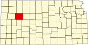 | |
| Ghost towns | ||
| Townships | ||
| Footnotes | ‡This community also has portions in an adjacent county or counties. | |
|
| This article about a location in Gove County, Kansas is a stub. You can help Wikipedia by expanding it. |