Iskushuban | |
|---|---|
Town | |
.jpg) The citadel | |
 Iskushuban Location in Somalia. | |
| Coordinates: 10°17′0″N 50°14′0″E / 10.28333°N 50.23333°E | |
| Country | |
| Region | Bari |
| District | Iskushuban |
| Government | |
| • Mayor | Musa Ali Musa |
| Population | |
| • Total | 7,000 |
| Time zone | UTC+3 ( EAT) |
Iskushuban ( Somali: Iskushubaan) is a small town in the northeastern Bari province of Somalia on the Horn of Africa. A historical settlement, it is situated in the autonomous Puntland state. It lies along the 50th meridian east.
Overview
Iskushuban is the centre of the Iskushuban District. It lies 80 km east of Qardho and 150 km south of Bosaso, the commercial capital of the Puntland region.
In the Arie valley, midway between the town and Qardho, once lay a sizeable city that had considerable structures with thick walls. [1]
Iskushuban is renowned for its seasonal waterfalls, which are the second largest in the country after those at Lamadaya in the northern Sanaag region.
In the early modern period, Iskushuban was a part of the Majeerteen Sultanate (Migiurtinia), centered in Aluula. [2] It was later incorporated into Italian Somaliland during the early 20th century.
Demographics
Iskushuban has a population of around 7,000 inhabitants. [3] The broader Iskushuban District has a total population of 45,027 residents. [4]
Education
Iskushuban has a number of academic institutions. According to the Puntland Ministry of Education, there are 8 primary schools in the Iskushuban District. Among these are Timirshe, Meeladeen, Gargoore and Iskushuban Primary. [5]
Gallery
-
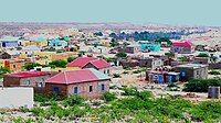 A view of Iskushuban
 -
 Entering main street
.jpg)
.jpg)
-
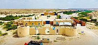 Front view of the Italian fortress/citadel
 -
 Italian stele in the citadel
.jpg)
.jpg)
-
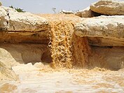 Iskushuban waterfalls
 -
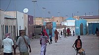 Main street

.jpg)
Notes
- ^ Hodd, Michael (1994). East African Handbook. Trade & Travel Publications. p. 640. ISBN 0844289833.
- ^ Hess, Robert L. (1966). Italian colonialism in Somalia. University of Chicago Press. p. 127.
- ^ "Somalia City & Town Population". Tageo. Retrieved 4 October 2013.
- ^ "Regions, districts, and their populations: Somalia 2005 (draft)" (PDF). UNDP. Retrieved 21 September 2013.
- ^ "Puntland - Primary schools". Ministry of Education of Puntland. Retrieved 26 May 2013.
References
|
| This Somalia location article is a stub. You can help Wikipedia by expanding it. |