Inverigo
Inverigh (
Lombard) | |
|---|---|
| Comune di Inverigo | |
.jpg) | |
 Inverigo Location of Inverigo in Italy  Inverigo Inverigo (Lombardy) | |
| Coordinates: 45°44′N 9°13′E / 45.733°N 9.217°E | |
| Country | Italy |
| Region | Lombardy |
| Province | Province of Como (CO) |
| Frazioni | Cremnago, Villa Romanò, Romanò |
| Area | |
| • Total | 10.0 km2 (3.9 sq mi) |
| Elevation | 232 m (761 ft) |
| Population (Dec. 2004)
[2] | |
| • Total | 8,209 |
| • Density | 820/km2 (2,100/sq mi) |
| Demonym | Inverighesi |
| Time zone | UTC+1 ( CET) |
| • Summer ( DST) | UTC+2 ( CEST) |
| Postal code | 22044 |
| Dialing code | 031 |
| Patron saint | Saint Ambrose |
| Website | http://www.comune.inverigo.co.it/ |
Inverigo ( Brianzöö: Inverigh [ĩʋeˈriːk]) is a comune (municipality) in the Province of Como in the Italian region Lombardy, located about 30 kilometres (19 mi) north of Milan and about 14 kilometres (9 mi) southeast of Como. As of 31 December 2004, it had a population of 8,209 and an area of 10.0 km². [3]
The municipality of Inverigo contains the frazioni (subdivisions, mainly villages and hamlets) Cremnago, Villa Romanò, and Romanò.
Inverigo borders the following municipalities: Alzate Brianza, Arosio, Brenna, Briosco, Carugo, Giussano, Lambrugo, Lurago d'Erba, Nibionno, Veduggio con Colzano.
Outside the town is the eclectic structure of Villa La Rotonda.
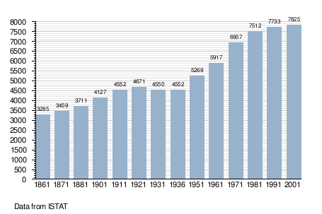
Demographic evolution
References
- ^ "Superficie di Comuni Province e Regioni italiane al 9 ottobre 2011". Italian National Institute of Statistics. Retrieved 16 March 2019.
- ^ "Popolazione Residente al 1° Gennaio 2018". Italian National Institute of Statistics. Retrieved 16 March 2019.
- ^ All demographics and other statistics: Italian statistical institute Istat.
| International | |
|---|---|
| Geographic | |
|
| This article on a location in the Province of Como is a stub. You can help Wikipedia by expanding it. |