Interstate 80 Business | |
|---|---|
| Cornell Avenue | |
BL-80 highlighted in red | |
| Route information | |
| Business route of I-80 | |
| Maintained by NDOT | |
| Length | 1.99 mi [1] (3.20 km) |
| Existed | 2000–present |
| Major junctions | |
| South end | |
| North end | |
| Location | |
| Country | United States |
| State | Nevada |
| Counties | Pershing |
| Highway system | |
| |

Interstate 80 Business (BL-80) is an interstate business route in Pershing County, Nevada. Serving the city of Lovelock along Cornell Avenue, BL-80 is also cosigned along portions of two other state highways through the city, State Route 396 (SR 396) from I-80 exit 105 to SR 856 at Airport Road and SR 856 from SR 396 at Upper Valley Road to I-80 exit 107.
Route description
BL-80 begins at the West Lovelock interchange with Interstate 80 and U.S. Route 95, concurrent with SR 396. The route follows Cornell Avenue north into the center of the town. The highway crosses Main Street ( SR 398) and continues along Cornell Avenue to its end at a five-point intersection with 14th Street, Airport Road ( SR 856) and Upper Valley Road near the Lovelock city limits. The highway heads northeast concurrent with SR 856 as Airport Road, crossing over Upper Valley Road, an irrigation canal, and the Union Pacific Railroad tracks before ending at a half-interchange with Interstate 80 and U.S. Route 95. [2]
-
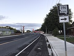 View along SR 396 near the north edge of Lovelock looking northbound
 -
 SR 396 in downtown Lovelock
 -
 View at the east end of SR 856 looking west
_in_Lovelock,_Nevada.jpg)
_near_Main_Street_(Nevada_State_Route_398)_in_Lovelock,_Nevada.jpg)

History
SR 396 was originally part of State Route 1 (SR 1). [3] That route, designated with the passage of Nevada's first highway law in 1917, created a highway route across northern Nevada from California to Utah which passed through Lovelock. [4] With the adoption of the U.S. Highway System in 1926,[ citation needed] US 40 was eventually added concurrently with SR 1. [3] [5]
With the advent of the Interstate Highway system, Interstate 80 (I-80) gradually replaced US 40 across northern Nevada and was removed from Lovelock by 1976. [6] Also around this time, the Nevada Department of Transportation was beginning to renumber its highways, eliminating the State Route 1 designation and redesignating the Lovelock portion on Cornell Avenue and Upper Valley Road as State Route 396. [3] Even though the cross-state designations of US 40 and SR 1 had been eliminated by the mid-1970s, construction of the Interstate 80 freeway in Lovelock was not started until 1981, so through traffic continued to use SR 396 in the city. [7]
Airport Road appears on maps as early as 1954, although it was not assigned a state highway number at the time. [8] The road was assigned to State Route 856 on July 1, 1976. [3]
The BL-80 designation was assigned in 2000.[ citation needed]
Major intersections
The entire route is in Lovelock, Pershing County.
| mi [1] | km | Destinations | Notes | ||
|---|---|---|---|---|---|
| 0.00 | 0.00 | Southern terminus; southern end of SR 396 concurrency | |||
| 0.94 | 1.51 | ||||
| 1.29 | 2.08 | Northern end of SR 396 concurrency, western end of SR 856 concurrency | |||
| 1.99 | 3.20 | Northern terminus, eastern end of SR 856 concurrency | |||
1.000 mi = 1.609 km; 1.000 km = 0.621 mi
| |||||
See also
References
- ^ a b "Maps of Milepost Location on Nevada's Federal and State Highway System by County" (PDF). Nevada Department of Transportation. May 2008. Archived from the original (PDF) on May 20, 2009. Retrieved August 9, 2009.
- ^ Nevada Department of Transportation (2011). Lovelock Area (PDF) (Map). Nevada Department of Transportation. Archived from the original (PDF) on January 18, 2017. Retrieved January 25, 2016.
- ^ a b c d Nevada State Maintained Highways: Descriptions, Index and Maps. Nevada Department of Transportation. January 2001. p. 113.
- ^ Statutes of the State of Nevada Passed at the Twenty-Eighth Session of the Legislature. Carson City, Nevada: State Printing Office. 1917. p. 312. Retrieved December 14, 2009.
- ^ Nevada Department of Highways (1937). Pershing County, Nevada (PDF) (Map). General Highway Map. Nevada Department of Highways. Sheet 1 of 2. Archived from the original (PDF) on February 15, 2017. Retrieved January 25, 2016.
- ^ Nevada State Highway Department (1976). Official Highway Map of Nevada (Map) (1976–1977 ed.). Nevada State Highway Department. Archived from the original on December 26, 2014. Retrieved December 14, 2009.
- ^ "NDOT News Spring 2006" (PDF). Nevada Department of Transportation. 2006. Archived from the original (PDF) on March 4, 2016. Retrieved January 25, 2016.
- ^ Nevada State Highway Department (1954). Pershing County, Nevada (Map). General Highway Map. Nevada State Highway Department. Sheet 1 of 2. Retrieved July 8, 2009.