This article relies largely or entirely on a
single source. (April 2021) |
Indian Village
| |
|---|---|
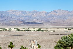
 Death Valley Indian Community, looking west toward the village from a hill one mile away across highway 190 | |
| Coordinates: 36°26′57″N 116°52′27″W / 36.44917°N 116.87417°W | |
| Country | United States |
| State | California |
| County | Inyo County |
| Location | Death Valley National Park |
| Habitat | Furnace Creek oasis |
| Elevation | −197 ft (−60 m) |
Indian Village is an unincorporated community in Furnace Creek, Death Valley of Inyo County, California. [1]
Indian Village lies at an elevation of 197 feet (60 m) below sea level. Indian Village is located in the Death Valley Indian Community reservation of the Death Valley Timbisha Shoshone Band of California, within Death Valley National Park. [1] Approximately 50 members of the tribe live in Indian Village.
After unsuccessful efforts to remove the band to nearby reservations, National Park Service officials entered into an agreement with Timbisha Shoshone tribal leaders to allow the Civilian Conservation Corps to construct an Indian village for tribal members near park headquarters at Furnace Creek in 1938.
References
Categories:
- Timbisha
- Native American populated places
- Death Valley
- Populated places in the Mojave Desert
- Unincorporated communities in Inyo County, California
- History of Inyo County, California
- Native American history of California
- Populated places established in 1938
- 1938 establishments in California
- Unincorporated communities in California
- Civilian Conservation Corps in California
- Indigenous peoples of North America stubs
- Inyo County, California geography stubs


