| Imuruk Lake | |
|---|---|
 Imuruk Lake | |
| Location | Seward Peninsula in Alaska |
| Coordinates | 65°35′29″N 163°11′49″W / 65.591349°N 163.196843°W |

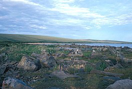
Imuruk Lake ( Inupiaq: Imaġruk or Narvaġruk) is the largest body of fresh water in Seward Peninsula in the U.S. state of Alaska. It measures 31 square miles (80 km2) and has a drainage basin of 102 square miles (260 km2), It lies on top of a lava plateau at an elevation of 960 feet (290 m). The drainage basin is relatively flat, as the maximum elevation is only about 1,600 feet (490 m). A low gap in the divide between the lake and the head of the right fork of Goodhope River rises only a few feet above the lake. The Fairhaven Ditch takes practically all its water from the lake. [1] Serpentine Hot Springs flow to the Serpentine River, 47 miles (76 km) northwest of Imuruk Lake. [2]
References
![]() This article incorporates text from this source, which is in the
public domain: US GPO's "Congressional serial set" (1913)
This article incorporates text from this source, which is in the
public domain: US GPO's "Congressional serial set" (1913)
- ^ US GPO (1913). Congressional serial set (Public domain ed.). United States. Government Printing Office. pp. 230–.
- ^ Orth, Donald J. (1967). Dictionary of Alaska Place Names, Geological Survey, Professional Paper 567. Washington: United States Government Printing Office.
